
Explorer Country - New South Wales

Under Mt. Brogden a member of the expedition planted oak, peach, apricot and quince seeds on the King's birthday to "serve to commemorate the day and situation, should these desolate plains be ever again visited by civilised man of which, I think there is little probability."
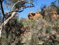
Of course, Oxley was wrong. Cocoparra is visited by thousands who come to see this dramatic part of the Australian landscape.
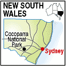
The park is located 25km. north-east of Griffith and is accessible from Rankins Springs off the Mid-Western Highway 14km. west of Rankins Springs. The Whitton Stock Route forms much of the western boundary of the park and is graded but not sealed. It was used extensively by Cobb & Co. coaches travelling between Melbourne and Queensland in the late 19th. century. After rain the roads in the park become slippery and boggy. Road conditions should be checked with the Griffith District Office of the National Parks and Wildlife Service 02 6927 755

