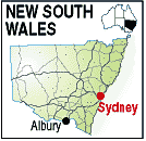
One of the highlights of a visit to the Albury/Wodonga region of New South
Wales is the activities you can enjoy on the River Murray. The river forms the
majority of the border between Victoria and New South Wales and reaches to just
below Adelaide in South Australia where it empties into the Southern Ocean.
From Albury the Paddle Steamer P.S. " Cumberoona" provides leisurly cruises
along the river from a wharf in the park at the western end of the city. The
parklands surrounding the landing have many picnic spots beside the river with
BBQ plates and seats to just relax and enjoy the river and the scenery. There
is also a resurrected Cobb and Co. office near the landing. Cobb & Co. were
mail and parcel carriers in the early days of settlement and had staging points
all over the country where horses were rested and changed, and mail and goods
were collected and deposited.
Albury also has a fine Art Gallery , a museum and many historic homesteads
and buildings to see. North of the city is the Ettamogah Sanctuary with native
fauna, and just off the road near the sanctuary, the wierdest hotel you will
ever see. Developed from a weekly cartoon by Ken Maynard in the Australian Post
magazine, it has been built, warts and all, to the artists specifications. A
truck is on the roof, and the walls are all concave. Definitely worth a visit
and photograph.
Albury is a busy regional centre providing services for a large agricultural
area. There are wineries to visit, and the massive Hume Dam just east of the
city on the river is a good place to spend some time. Albury Wodonga is also
only an hour or so from the ski fields of Victoria and New South Wales. If you
are in the region in winter it is well worth a visit.
The information centre is located between the two cities on the causeway.
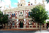
Albury has many iisted heritage buildings including the
following from the Register of the National Estate.
Albury is the birthplace of women's tennis grand slam winner Margaret Court, abd 2003 & 2007 WNBA MVP winner Lauren Jackson.
- Albury Public School, circa 1861
- ANZ Bank, designed by Walter Butler, circa 1915
- Bellevue Home, circa 1860
- Burrows House, circa 1860
- CML Building, circa 1930
- Court House, designed by Alexander Dawson, circa 1860
- Headmaster's Cottage, Kiewa Street
- Post Office, circa 1875
- Public School, designed by W.E.Kemp, circa 1881
- Railway Station, circa 1881
- Railway Stationmaster's Residence, circa 1881
- S M Abikhair Haberdashery Store, circa 1917
- Soden's Hotel Australia, circa 1855
- T&G Building, circa 1935
- Technical College (formerly Telegraph Office), circa 1885
- Town Hall, circa 1907
- Turk's Head Museum (formerly Turk's Head Hotel), circa 1860-70
PLACES OF INTEREST:
The main attractions in Albury are listed below with some links
to further information on them.
- Albury Botanical Gardens
- Albury Regional Museum
- Australian Jewellery Company
- Australia Park
- Cobb & Co. Coaches
- Eastern Hill Lookout
- P.S. "Cumberoona" Cruise on the River Murray
- Ettamogah Sanctuary
- Ettamogah Pub
- Hovells Tree and Reserve
- Hume Weir & Dam
- Hume Weir Trout Farm
- Leadlight Pottery and Craft
- Monument Hill Lookout
- National Museum of Australian Pottery
- Norieul Park
- Port of Albury
- RAOOC Museum, Bandiana, Army Museum, 5km. from Wodonga
- Sumsion Gardens
- Willow Park
- Wineries
INFORMATION CENTRE:
Gateway Tourist Information Centre
Lincoln Causeway (Hume Hwy), Wodonga. Victoria 3690
Telephone: 02 6041 3875 (Open 7 Days)
HOW TO GET THERE:
Take the Hume Highway (31) from Melbourne or Sydney.
There is a domestic airport.
Rail from Melbourne or Sydney
ABOUT ALBURY
Twin town with Wodonga on the river Murray 300km. north of Melbourne.
Gateway to the alps. Albury was first noted by explorers Hume and Hovell in 1824. The Albury Regional
Museum exhibits cultural and historic displays of the area. Monument Hill offers a full panorama over
the city and the PS Cumberoona provides cruises on the river. The Albury Regional Art Gallery
has an extensive collection of paintings by Russell Drysdale.
CLIMATE
Albury has a warm, temperate, four-season climate, with cool to mild winters and very warm to hot summers.
In summer, the mean daily maximum temperature is around 30 degrees Celsius with low humidity; however,
this is subject to substantial daily variation. An average of 17 days with a maximum above 35 degrees
Celsius occur in this summer period. Mean winter maximums are around 14 degrees Celsius. Frosts are
commonplace in winter, with approximately 20 days per year featuring minimums of below freezing.
The city has a number of suburbs.
Central Albury comprises the central business district (CBD) and lies between the railway line, the
Murray River and Monument Hill. Much commercial activity is concentrated here, with Dean Street
forming the axis of the main shopping and office district. A cultural precinct is centred around QE2
Square, including the Albury Library Museum, Albury Regional Art Gallery, Albury Performing Arts
Centre and Convention Centre, and the Murray Conservatorium. In the same block are the Post Office,
Police Station and Courthouse, as well St Matthew's Anglican Church which was rebuilt after being
destroyed by fire in 1990. The Albury City council offices are located on Kiewa Street.
Forrest Hill lies directly north west and covers the saddle between Monument Hill and Nail Can Hill,
whilst west over the ridge lies West Albury. West Albury is primarily a residential area, but it is
home to the First World War Memorial (locally known as the Monument), Riverwood Retirement Village,
Albury Wodonga Private Hospital (which lies on the corner of Pemberton Street and the Riverina Highway),
and the Albury sewerage treatment plant. All of West Albury was once wetland and bush. The only remnant
of this is Horseshoe Lagoon to the south-west of the suburb, which has been declared a Wildlife Refuge
by NSW Parks & Wildlife and incorporated into the Wonga Wetlands. To the north-west of West Albury
is Pemberton Park.
East Albury lies east of the railway line/freeway from the CBD and houses cover the Eastern Hill
alongside the Albury Base Hospital, while the flat land directly north of it is covered by parkland,
housing and light industry, and a retail park including Harvey Norman and Spotlight franchises, as
well as the city airport. The Mungabareena Reserve lies on the Murray south of the airport, and is
considered an Aboriginal cultural site of some significance. Mungabareena means "place of plenty
talk" in the Wiradjuri language.
South Albury is a mix of residential and industrial areas, with the floodplains south of the railway
line and freeway still used for farming and grazing. Flood mitigation works in the 1990s have dramatically
reduced the risk of flooding in the residential areas of South Albury.
North Albury was once covered by orchards and vineyards in the first half of the 20th century, as was
a swamp where the James Fallon High School now stands, but after the second world war housing development
in the area increased and Waugh Road was extended from David Street to the "Five Ways" intersection at
Union Road, which ascribes the border between North Albury and Lavington. The locality of Glenroy is
adjacent to North Albury, west of the Bungambrawartha Creek, and housing development was developed in
the 1970s, including a significant Housing Commission public housing estate.
Lavington is the largest suburb of Albury, and the only suburb which has its own postcode (2641, as
opposed to 2640 for the balance of Albury). The suburb was originally named Black Ridge in the 1850s
and 1860s, before being renamed Lavington in 1910.[10] Originally within the boundaries of Hume Shire,
it was absorbed into the City of Albury Local Government Area in the 1950s. Housing and commercial
development has continued from that point until this day. Prior to 2007, the Hume Highway - also known
as Wagga Road - passed north-east through the suburb, with Urana Road passing north-west though the
suburb from the "Five Ways" or "Roundabout" road junction. In 2007, an internal bypass of the Hume
Freeway was opened [11], with the former name of the Hume Highway section officially reverting to
the commonly used "Wagga Road". The suburb of Lavington also includes the localities of Springdale
Heights, Hamilton Valley and Norris Park. A lawn cemetery and crematorium lies at the western end of
Union Road.
Thurgoona, to the east of Lavington, was established as a new residential suburb by the Albury Wodonga
Development Corporation in the 1970s. In the 1990s a new campus of the Charles Sturt University was
established here, as was an office of the Murray Darling Freshwater Research Centre. A major golf
club known as the Thurgoona Country Club Resort is also situated in this suburb.
Lake Hume
Lake Hume is situated on the Murray River 10 kilometres upstream of Albury. The Hume Weir wall
construction took 17 years, from 1919-1936. A hydro-electric power plant supplies 60 MW of power
to the state grid. When full the lake covers 80 square kilometres.
The lake was created for irrigation purposes and has caused significant changes to the flow patterns
and ecology of the Murray River. Before the construction of the Hume Weir, flows in normal (non-drought)
years were low in summer and autumn (though still significant overall), rising in winter due to seasonal
rainfall and reaching a flood-peak in late spring due to snowmelt in the Murray and tributaries' alpine
headwaters. The flow is effectively reversed now, with low flows in winter and sustained, relatively high
flows in late spring, summer and early autumn to meet irrigation demands, although the spring flood peak
has been virtually eliminated. In addition, the water released from the base of the Hume Weir is
unnaturally cold. This flow reversal, temperature depression and removal of the spring flood peak has
led to the drying out and loss of many billabongs and has harmed the populations of native fish of the
Murray River such as the iconic Murray Cod.
History
Explorers Hume and Hovell arrived at what is now known as the Murray River at Albury on 16 November
1824 what their maps named 'Crossing Point'. They named the river the Hume River and the next day
inscribed a tree by the riverbank before continuing their journey south to Westernport in Victoria.
In 1829, explorer Captain Charles Sturt discovered the Hume River downstream at its junction with the
Murrumbidgee River. Not realising it was the same river, he named it the Murray River. Both names
persisted for some time, Hume falling into disuse eventually in favour of Murray. A crossing place for
the Murray became popular close to where Hovell inscribed
the tree. In summer it was usually possible to cross the river by foot.
|
|