 |
Gulgong NSW 2852 |
|---|---|
|
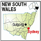
Population: 2017, Height above sea level: , Latitude: 32.22.00, Longitude: 149.32.00 Location: 310km north west of Sydney Highway: South of Golden Way (84) and east of Mitchell Hwy (32) Nearest Major Town: Mudgee Nearest Airport: Dubbo Touring Area: Central West - Explorer Country | |
|
Gold was discovered in 1866 and by 1872 there was a local population of around 20,000.
Today, much of this history, with its buildings, is preserved and the National Trust has
classified around 130 of the towns buildings. The Pioneers Museum is an extensive folk museum recording and displaying the towns past. Exhibits include two cottages, whole rooms as they were, and a blacksmiths shop. The Henry Lawson Centre exhibits 'A Walk Through Lawson's Life', with original manuscripts, artefacts, photographs and memorabilia. | |
 |
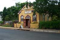 Henry Lawson Centre - Gulgong |
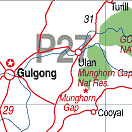
| To see a map of the town, click on the top map, for a map of the area, click on the bottom map, for more information about the town, click on the photograph. | |
 |
© Copyright Wilkins Tourist Maps Pty Ltd | |