 |
Kiandra NSW 2630 |
|---|---|
|
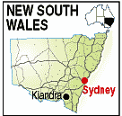
Population: 10 Height above sea level: 1,400m Latitude: 35.52.00, Longitude: 148.30.00 Location: 490km south of Sydney Highway: Snowy Mountains Hwy (18) Nearest Major Town: Cooma Nearest Airport: Cooma Touring Area: Snowy Mountains | |
|
Located in the Snowy Mountains National Park on the banks of the Eucumbene River
this small, abandoned goldrush town is between Tumut and Cooma. Goild was found in
1859 by the Pollock Brothers and the ensuing rush found some 10,000 miners trying
their luck in the harsh conditions. it is estimated that at its peak there were around 15,000 people around the Kiandra fields, with 25 stores, 13 bakeries, 16 butchers, 14 pubs, several banks and four blacksmiths. The last mines closed in 1906. Originally named Gibsons Plains after an early settler, restoration work is ongoing by the National Parks and volunteers in an effort to restore it as a place of historical significance. It was once Australia's highest town. | |
 |
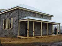 The restored Kiandra Courthouse. Photo - Wikipedia. |
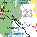
| For a map of the area, click on the bottom map. | |
 |
© Copyright Wilkins Tourist Maps Pty Ltd | |