 |
Kyogle NSW 2474 |
|---|---|
|
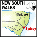
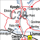
Population: 3,000, Height above sea level: , Latitude: 28.3700, Longitude: 153.0000 Location: 760km north of Sydney Highway: Summerland Way (91) off Bruxner Hwy at Casino Nearest Major Town: Casino Nearest Airport: Casino Touring Area: Northern Rivers & Tropical NSW | |
|
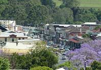
Surrounded by some of the most impressive rainforest in New South Wales and
on the upper reaches of the Richmond River, Kyogle was established as a timber town in 1830. Kyogle is a pretty and strategically located town with much to offer the visitor. Near Mt Fairy, the Captain Cook Memorial Lookout atop the mountain has stunning views. A botanical gardens will be found in the town on the banks of Fawcetts Creek. The nearby Border Ranges and Toonumbar National Parks are popular places to spend a few days. | |
 |
 |
| For a map of the area, click on the bottom map. | |
 |
© Copyright Wilkins Tourist Maps Pty Ltd | |