 |
Maclean NSW 2463 |
|---|---|
|
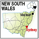
Population: 2.650, Height above sea level: 100m Latitude: 29.2800, Longitude: 153.1200 Location: 670km north of Sydney. Highway: Pacific Hwy (1) Nearest Major Town: Grafton Nearest Airport: Grafton Touring Area: Northern Rivers & Tropical NSW | |
|
As its name indicates Maclean has a proud Scots Heritage and calls itself a Scottish Town
demonstrated by hundreds of telegraph poles painted in different clan tartan colours.
Near the Bundjalung and Yuraygir National Parks it is a popular tourist destination
offering surfing, swimming, golf and other activities. Maclean is located on the Clarence River. Visitors should take in the panoramic views of the town, coast and bushland at the Maclean Lookout and explore nearby Pinnacle Rock, a fascinating rock formation with a network of caves. The Maclean Cane Harvest Festival is held annually (usually during the Sep-Oct NSW school holidays) and the famous Highland Gathering at Easter. | |
 |
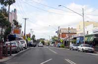 |
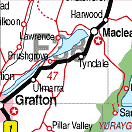
| To see a map of the town, click on the top map, for a map of the area, click on the bottom map, for more information about the town, click on the photograph. | |
 |
© Copyright Wilkins Tourist Maps Pty Ltd | |