 |
Mudgee NSW 2850 |
|---|---|
|
Population: 8,600, Height above sea level: , Latitude: 32.36.00, Longitude: 149.35.00 Location: 282km west of Sydney Highway: Castlereah Hwy (86) Nearest Major Town: Mudgee Nearest Airport: Mudgee Touring Area: Central West - Explorer Country | |
|
Located on the Cudgegong River it takes its name from the aboriginal 'muthi' meaning 'nestled
in the hills'. Many well preserved Victorian era buildings exist and the Mudgee wine growing
area offers plenty to do. The Colonial Inn Museum has memorabilia, machinery and photographs of the past and the Honey Hive has local honey and mustards from this highly productive area. | |
 |
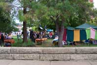 The Mudgee Market is a popular place to visit. |
| To see a map of the town, click on the top map, for a map of the area, click on the bottom map, for more information about the town, click on the photograph. | |
 |
© Copyright Wilkins Tourist Maps Pty Ltd | |