| PEAK HILL - NEW SOUTH WALES - 2869 | ||||
|---|---|---|---|---|
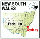 |
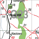
Population: 1,500 Height above sea level: 400m Latitude: -32.4400 Longitude: 148.1100 Location: 415km north west of Sydney Highway: Newell Hwy (39) Nearest Major Town: Dubbo Nearest Airport: Dubbo Touring Area: Central West - Explorer Country |
 |
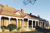 Peak Hill Hospital | |
 | ||||
|
Located on the Newell Highway between Parkes and Dubbo, Peak Hill offers traveliers an enticing break.
Stop a while, stretch your legs and enjoy the main street's craft and coffee stops. Peak Hill is
also a great base for staying overnight and day tripping to nearby attractions such as the Western
Plains Zoo, The Dish and Goobang National Park. Peak Hill is a little town with a big heart of gold! The town's history is indelibly linked with the discovery of gold in 1889. 'Dig around' a little - the Visitor Information Centre is a great spot to start, and you'll find the story of Peak Hill's golden history is not far below the surface. The Peak Hill Visitor Information Centre is in Caswell Street and shares a building with the Country Crafts store. This is a great place to pick up a locally made souvenir from amongst the delightful range of hand-made crafts and gifts. The Centre also features an interesting display of the late Ray Merton's photographs depicting the mining history of Peak Hill. Peak Hill is rich in arts and crafts, and a stroll just across the road from the Visitor Information Centre reveals an unexpected delight. Here, Sugar n Spice is more than just the quaint café it appears to be, you'll find there's a gallery of porcelain dolls, pieces of fine porcelain ware and other crafts on display. The Rusty Shed Gallery and the Antiques stores along the main street are also worth a visit. The Carrington Hotel (also in Caswell street) has been partly restored since a fire saw the last of it's beers poured back in 1997. The building has been re-birthed to now house the Peak Hill Community Technology Centre (CTC). The CTC is a great spot to stop and check your emails, with internet access available Tuesday to Fridays. The Peak Hill Tourist Drive and Map is available at the Peak Hill and Parkes Visitor Information Centres. The Tourist Drive will guide you to some interesting locations just off the main street, to explore treasures such as Australia's first public wheat silos (1918) which are still operating today. Also along the Tourist Drive is the hospital, which is visible from the highway on the southern approach to town. The Peak Hill Hospital was built at the turn of the century (1904) and is now listed with the National Trust. If you're looking for a picnic spot, Memorial Park, (on the main street adjacent to the Bowls Club) is a well maintained park with gardens, picnic tables, electric BBQ and toilets. Alternately Bogan Weir is a great spot for a waterside picnic. Just 6km west of town, Bogan Weir offers shady picnic areas and provides pleasant opportunities for bird watching, canoeing and fishing. On the eastern side of town the Golf Club boasts state-wide recognised sand greens and incredible views to match. The Club overlooks the stunning Hervey Ranges to the east, which are part of Goobang National Park. On the road to the Golf Club is the Fauna and Flora Park. Originally one of the old alluvial mine workings, the Park now provides opportunity to enjoy a variety of birdlife and flora such as the colourful orchids seen in the cooler months. Experience first hand why Peak Hill is known for its merinos and wheat - visit Westray Farmstay, a working sheep stud. Westray offers on-farm accommodation and the opportunity for group farm tours by appointment. Peak Hill's open cut gold mine sits atop the hill overlooking the town. While the mine is now inactive, there was a recent period of intense mining here, more than a century after the initial gold discoveries. We apologise - the mine viewing platform and walking-trail were not open at the time of printing this publication, with future opening dates unknown. Goobang National Park Goobang National Park is located just east of Peak Hill, or 30 kilometres north-east of Parkes. At approximately 42,600 hectares in size, it forms the largest area of remnant vegetation in the Central West of New South Wales. Travellers on the Newell Highway between Tomingley and Parkes can see the Park to the east. Activities: Bushwalking, bird watching, 4WDriving and camping. More than 300 plant species have been recorded in the park, including 40 species of orchids. Caloma Trig lookout offers fantastic views of the surrounding countryside. The National Park can be accessed via the Tomingley-Yeoval Road in the north, the Parkes-Manildra Road in the south and from Peak Hill along the Baldry Road in the centre. The park's main trails are accessible to 2WD vehicles, however they can become very boggy after heavy rain. Trails beyond the campsites and to Caloma Trig are accessible via 4WD only. Camping: Wanda Wandong Camping Ground in the northern section, 700m off the Tomingley-Yeoval road. Generally suitable for 2WD cars, except in wet weather. This campground is in an open woodland with a grassy understorey. Greenbah Camping Ground in the northern section, via Sawpit Gully Trail, off the Trewilga-Baldry road. Generally suitable for 2WD cars, except in wet weather. Beside Greenbah Creek, it's excellent for birdwatching. Walk to Burrabadine Peak, or cycle along the access trail to the campground. EVENTS CALENDAR MAY JUNE AUGUST NOVEMBER PLACES OF INTEREST:
|


© Copyright Peter W. Wilkins