 |
Wootton NSW 2423 |
|---|---|
|
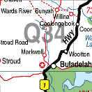
Population: 50, Height above sea level: , Latitude: 32.18.00, Longitude: 152.18.00 Location: 255km north of Sydney Highway: Off Pacific Hwy (1) at Bulahdelah (15km) Nearest Major Town: Newcastle Nearest Airport: Newcastle Touring Area: North Coast NSW | |
|
Near the Wallingat National Park and Myall Lakes, this small hilltop town is an ideal
touring centre for the region. The Wang Wauk Forest Drive begins here and the
Wootton Railway Historical Walk is an inviting challenge. Wootton is situated 10kms north of Bulahdelah on the old Pacific Highway, now called Wootton Way Surrounded by cattle farms, horse studs, state forests and national parks it is an active community. The extensive forests are perfect for bike riding and trekking. The 6km Wootton Historical Railway Walk can be found in the Wang Wauk State Forest beginning at Sam's Camp Picnic Area, with Wang Wauk Forest Way marking its halfway point. The first section of the walk takes in rainforest and cleared, grassy areas used by logging vehicles in the early 1900s. There are significant remnants of old logging railways, mossy bridges, waterfalls, creeks and rainforests. The walk finishas at the remains of what was once a trestle bridge. | |
 |
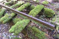 Part of the old logging railway. |


© Copyright Peter W. Wilkins