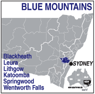
EXPLORING THE BLUE MOUNTAINS REGION.
Take the Great Western Highway or the M6 west of Sydney through Penrith, across the Nepean River to join the eastern base of
the Great Dividing Range and the beginning of the Blue Mountains Touring area.
The highway crosses the range travelling through pretty mountain villages and towns to descend to Lithgow at the western base of
the ranges. From Sydney to Penrith is around 55km and from Penrith to Lithgow another 90. Katoomba, the hub of the area, is
100km from Sydney Centre.
The return trip from Lithgow or Mt Victoria can be by the Bells Line of Road which climbs the mountains north of the highway and passes
through Bell, Bilpin and Kurrajong then descends to historic Richmond and Windsor on the Hawkesbury River.
Trains run regularly from Sydney to the Blue Mountains and Lithgow from Central Station and points along the line including Parramatta,
Penrith and Katoomba.
Coming from the south (Melbourne) you can turn off at Goulburn on the Hume Hwy and take the road through Oberon to join
the highway at Lithgow, and from the north the Putty Road leads from Maitland to Richmond. Both roads avoid the Sydney traffic.
Wilkins Tourist Maps produces a free map of Lithgow and area which you can download as an swf (Flash file)
from the Free Downloads button on the front page or pick up from the Information Centre in Lithgow.
Select a touring route from below to automatically open it on this page.