A tour of the Western MacDonnell Ranges with its numerous gorges, chasms, waterholes and spectacular scenery will enhance your stay in The Centre, While it is possible to see much of what the ranges have to offer on a day return trip, it is recommended that you either stay overnight at Glen Helen Lodge, or camp at their caravan park and return the next day.
To explore these ranges, leave Alice Springs along Larapinta Drive, cross the railway line and drive out past the Diarama Village, heading west along the range. Several kilometres out you will see the highest point of the range, Mt. Gillen, and directly beneath it, the grave of Rev. John Flynn (Flynn of the Inland-see separate story). The grave is capped by one of the Devil's Marbles, transported from near Wauchope, on the way to Tennant Creek. Continue along the Larapinta Drive for another 10km., and on your right is the access road to Simpson's Gap National Park. A little way along this road is an information centre, and the gap is some 7km. from the main road. Simpson's Gap is one of the most frequently visited in the ranges and a colony of Rock Wallabies can usually be seen there on the steep hillside to the right of the riverbed leading to the water-hole in the Gap. Toilets, barbecue facilities and picnic facilities are provided for your comfort.
Back at the main road, and nearly opposite, is Honeymoon Gap, a popular picnic spot for locals, but having no facilities. A track runs through this gap leading to a road which will return you to Alice Springs along the back of the ranges, joining the Stuart Highway just south of Heavitree Gap. Both Simpson and Honeymoon Gaps are situated on Roe Creek, which you will cross immediately after rejoining Larapinta Drive heading west. Just beyond Roe Creek, to the left, are the Twin Gums, two similar ghost gums which are a popular subject for photographers and artists.
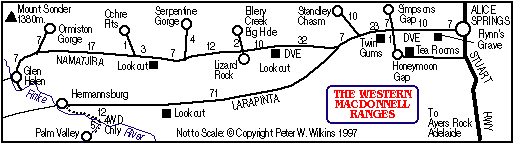
Continue west for another 23km. to the Standley Chasm turn off. Standley Chasm is located 10km. north of the main road. It is now managed by representatives of Iwupataka, an aboriginal settlement on nearby Jay Creek, and is one of the most publicised attractions in Central Australia. From the kiosk, picnic area and carpark, you will walk some 800 metres along the stony riverbed to reach the chasm, which is best photographed at noon when the sun is directly overhead. An entrance fee is charged to the chasm area and the park is open from 8.30 am until 5.00 pm daily. Drinks, sandwiches, souvenirs and films are available from the kiosk.
Returning to the main road, continue west across Jay Creek, past the settlement on your right, to Namatjira Drive, which joins the road 47km. from Alice Springs.
Some 11km. along this road you will cross the usually dry Hugh River,. If you look carefully you will see bruise marks high on the trees in the riverbed indicating the height of the flooding which besieges this typical Central Australian river after heavy rains. Another 21km, and you will find a roadside stop and panoramic lookout to your left. You are now 79km. from Alice Springs and 54km. from Glen Helen. The panorama of the ranges from this vantage point is magnificent and facilities are provided for picnics.
Leaving this lovely spot, travel another 10km. to the Ellery Creek Big Hole Nature Park turn-off. Opposite the turn-off is an unusual rock formation known locally as 'Lizard Rock'. Proceed 2km, down the access road to Ellery Gorge where facilities are provided and, if you wish, swim in the waterhole at the gorge. A word of warning here, the water temperature gets colder with the depth of the water, so don't dive deeply.
Return to the main road and continue another 12km. to Serpentine Gorge road, an unusual and beautiful gorge 4km. from the main road where Ansett once had a tourist chalet. Here you will now find barbecues and toilet facilities.
Another 7km. from the turn-off along Namatjira Drive is a second look-out and roadside stop offering the reverse view back along the valley. Water, barbecues and shelters will be found here.
Rejoining the main drive, another 3km will find you at the turn-off to the Ochre Pits, source of painting materials of aboriginals for centuries. Brilliantly coloured, the natural ochres in the cliff face are a must for the photographer and a pleasant respite for the visitor before rejoining the road for the next 17km. to the Ormiston Gorge turn-off. The beautiful mountain you will see ahead of you in the distance as you approach the turn-off is Mt Sonder, and is the subject of many paintings by the famed aboriginal artist and Arnada tribesman, the late Albert Namatjira, after whom the drive is named.
Ormiston Gorge is probably the most spectacular of the gorges in the range and the adventurous can spend many hours exploring the pound which runs east from the large waterhole at the gorge.
The area is rich in flora and fauna and facilities including barbecues and toilets can be found at the car park near the gorge.
Returning to the main road you are now only a few kilometres from Glen Helen where accommodation, meals, drinks and friendly hosts await you. On your tour you will have seen much of what makes Central Australia a unique part of the nation and will have experienced what has been captured in oils, water colours and on film by millions before you.


