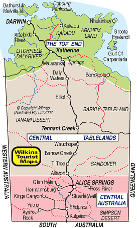
   Northern Territory Map Barkly Highway (66) Townsville to Tennant Creek Stuart Highway (Adelaide to Alice Springs) (87) Stuart Highway (Alice Springs to Elliot) (87) Stuart Highway (Elliot to Darwin)(87) 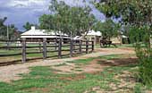 |
| THE TOP END Kakadu, Katherine Gorge, Arnhem Land, Mataranka, Elsey, Litchfield |
|---|
|
The Top End of Australia is centred around Darwin and includes the World Heritage Kakadu National Park, Arnhem Land,
the Litchfield National Park, Katherine Gorge, the Mataranka Hot Springs, Old Elsey Station and the characters of Aeneas
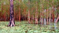
Gunn's 'We of the Never Never', the Gove Peninsula and numerous springs and waterfalls. This is crocodile country and visitors should take care when swimming in the sea or inland rivers. The most popular destination is the Kakadu National Park located some 250km south east of Darwin along the Arnhem Hwy. Depending on the time of year you visit you will see vast wetlands, stunning waterfalls, prolific wildlife and the stark escarpment which limits its eastern boundary. The Katherine Gorge is located around 300km south of Darwin along the Stuart Hwy and east of the road. The Katherine River has cut a series of massive gorges through the rock and the experience of taking a cruise along them is exhilarating. Jedda's Rock is one of the main features and those who remember the film about an aboriginal girl named 'Jedda' will find it fascinating. Johnston River Crocodiles inhabit the gorges and can be seen basking in the sun on rocks along the way. These are not man-eaters and a popular activity is to walk to the head of the gorges and float down on a li-lo to the main access point. The Mataranka Hot Springs bubble from the ground and are crystal clear. They are set amongst tropical trees and vegetation and definitely worth a visit. Also at Mataranka is a replica of the Old Elsey Homestead, used in the film of Gunn's book. South of Katherine are the Cutta Cutta Caves, Limestone caves located beside the highway and easily accessible. The Top End is semi-tropical and very humid in summer. The 'WET' season runs from around the end of November to March and heavy downpours occur most afternoons. I suggest you time a trip to the Top End for March or April when it is cooler and plenty of water remains in billabongs and over waterfalls. |
| CENTRAL TABLELANDS Tennant Creek, Lake Woods, Newcastle Waters, The Tanami, Devils Marbles |
|
The Central Tablelands is centred around Tennant Creek and stretches from Mataranka in the north to Aileron in the south, 100km north
of Alice Springs. It also reaches the Western Australian and Queensland borders to the west and east. Mostly arid and desert area with a few cattle, in recent years a
thriving agricultural industry has sprung up at places like Ti Tree. Tennant Creek was another town set up as a station on the telegraph line and later flourished with mining. At the junction of the highway for travellers to and from Queensland it is now a tourism destination for people heading north or south along the road. The area contains the small settlement of Elliot, with nearby Lake Woods, and Newcastle Waters in the north and the Tanami Desert in the west. In the south places to see are the old telegraph station and graves at Barrow Creek. The graves are of linesmen at the station who were attacked and killed by aboriginals. There is a hotel here and nearby is the spot where English tourist Peter Falconio went missing in July, 2001. To the north are small settlements providing services to travellers including the historic Daly Waters Pub, just off the highway and filled with artifacts and curios. There are several monuments along the road including one where the telegraph line was joined in 1872, one at Three Ways to Rev. John Flynn, one at Attack Creek where John McDouall Stuart and his party were ambushed by aboriginals in a quest to find a way across Australia south to north, and one near Wauchope indicating Central Mt Stuart, nearby the geographical centre of Australia. WARNING: Much of the road is unfenced and cattle, kangaroos and camels may appear suddenly from bushes beside the road. Drive sensibly |
| CENTRAL AUSTRALIA Alice Springs, Ayers Rock, Kings Canyon, MacDonnell Ranges, Palm Valley |
|
Central Australia, and particularly Ayers Rock (Uluru), is one of the world's great destinations. Established
as a repeater station on the overland telegraph line connecting Australia with the rest of the world, it has grown into major touring area offering stark red mountain ranges,
cool waterholes in hidden gorges, outback roadhouses and homesteads offering down to earth accommodation and experiences, camel rides, unusual festivals like the Henley on
Todd race where participating teams pick up bottomless boats and race along the riverbed to the cheers of thousands of onlookers. Ayers Rock is around 450km south west of Alice Springs and along the way is the remarkable Kings Canyon, a spectacular gorge in the George Gill Range cut by Kings Creek and offering wonderful walks among ancient formations. There are also waterholes and a waterfall. It is one of my favourite spots in Central Australia. Of course, around Alice Springs itself there is much to see and do. Visit the Old Telegraph Station, see the Arid Zone Gardens, find out the history of the Reverend John Flynn who opened up the outback with the aerial medical service. You can visit the Royal Flying Doctor Service and School of the Air to see how they operate. Among the most popular trips in the centre is an exploration of the MacDonnell Ranges which stretch east an west of the city. Numerous gorges, gaps, waterholes, unusual rock formations and remote ruins make this fascinating. Central Australia is also where aboriginal artist Albert Namatjira painted and there are galleries and exhibitions of aboriginal art and culture everywhere. A truly fascinating area you must visit. For things to see and do around Alice Springs follow this link. |
 |
© Copyright Peter W. Wilkins | |