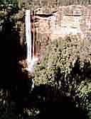
The Fitzroy Falls

|
The Morton National Park is located south of Mittagong in the Southern Highlands and straddles the Shoalhaven River. It contains several waterfalls, many walks, camping areas, picnic spots and rainforest.
Gambells Rest: Bundanoon
(Camping, hot showers (fees apply, bookings essential), fireplaces, picnic areas walking tracks)
There are 14 walking tracks from Gambells Rest:
Erith Coal Mine: 1 hour return, Short, steep, with woodland, heath and rainforest
Echo Point Rd: 40 mins. return. Shorter then above, but steeper.
Echo Point Rd Bonnieview (Loveris Walk): 1 hour return. easy walk with views across the gully.
Echo Point Picnic Area, Mount Carnarvon: 30 mins. return. After a short descent, easy walk
along a ridge to a lookout.
Grand Canyon: Fern Glen: 15 mins. return. Short, easy walk to a damp, rocky area.
Tooths Lookout to Bundanoon Creek: at least 2 hours return. Very steep with magnificent views.
Access to Bundanoon Ck and rocky pools.
Track Junction, below Fairy Bower Falls: 30 mins. return. Easy walk joining the Cliff Climb from
Tooths Lookout to the base of Fairy Bower Falls
Fairy Bower Carpark- Fairy Bower Falls: 40 mins. Steep track to a waterfall with steps to the
base of the falls
Scenic Circuit- Fairy Bower Falls: 30 mins.. (Steep steps at falls) Through open forest to the
falls
Nicholas Pass-Fairy Bower Falls: 30 mins. return. Undulating scenic track
Amphotheatre - Riverview: 20 mins. Easy walk across Fern Tree Gully to a dry eucalypt forest
Dimmocks Creek Track: 30 mins. return. Easy walk to the head of Dimmocks Creek
Glow Worm Glen: William St. Bundanoon. 1 hour return. Steep track, glow worms only visible
after dark. Torch essential, reflective markers along the track point the way.
Riverview Rd- Glow Worm Glen: 40 mins. Alternative day walk to the glen.
Carrington Falls 8 km. south east of Robertson a turn-off takes you along the Jamberoo Pass Rd
towards Kiama. A left turn at the fork 2km. along the road will take you to Thomas' Place picnic area and
lookouts, while the right fork leads to Nellies Glen picnic area.
There are 3 lookouts along the eastern rim from the carpark at Thomas' Place in a 2km. return walk
(about 2 hrs.), with excellent views over the falls.
Belmore Falls: Folow the Myra Vale Road from near Fitzroy Falls 7km. to a junction with the
Belmore Falls Rd. to your right. 4km. along the road is the Barrengarry Creek Crossing and the carpark
for the falls is about 1km., further on. A track leads from here to 4 lookouts.
Manning Lookout: 1 km. south of the Myra Vale Rd turn-off, this short rd leads to a carpark
and a walking track which offers 3 lookouts with extensive panoramas over the Kangaroo Valley
|
