| AUGATHELLA - QUEENSLAND - 4477 | ||||
|---|---|---|---|---|
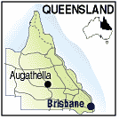 |
Population: 750, Latitude: 25.48.00 Longitude: 146.35.00 Location: 750km north west of Brisbane Highway: Landsborough Hwy Nearest Major Town: Charleville Nearest Airport: Charleville Touring Area: Outback |
 |
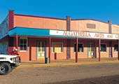 Augathella - Courtesy of Tourism Queensland | |
 | ||||
|
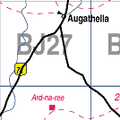
Augathella is on the Warrego River in Outback Queensland, west of Brisbane on the Matilda Highway
some 85 km. above
Charleville. Just west of the Great Dividing Range, it is mainly cattle country and is central
to the Scrubby Creek Conservation Reserve, Chesterton Range National Park, and the Carnarvon
National Park. There is a Royal Flying Doctor Base at Charleville which is open to visitors. PLACES OF INTEREST: ACCOMMODATION & SERVICES: 
|


© Copyright Peter W. Wilkins