 |
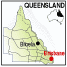
Biloela QLD 4715 |
|---|---|
|
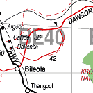
Population: 5.800 Height above sea level: 176m Latitude: 24.2502 Longitude: 150.3010 Location: 142km SE of Rockhampton. 600km north of Brisbane Highway: Access along the Leichhardt Hwy (39) and The Country Way (17) Nearest Major Town: Rockhampton Nearest Airport: Rockhampton Touring Area: Capricorn Coast | |
|
In the fertile Callide Valley, south of Rockhampton, it is a major cotton,
lucerne and sorghum producing area. There are several historic buildings and the Greycliffe Homestead to visit. The name comes from the aboriginal for White Cockatoo. Biloela is the administrative centre of Banana Shire and was gazetted in 1924 and a post office opened in the following year. Beef cattle, cotton and sorghum are the main crops. There is an abattoir and coal mines at Callide which provide fuel for the power station. The Callide Dam is where the largest recorded Barramundi was caught in 2008 measuring 138cm. | |
 |
 |


© Copyright Peter W. Wilkins