| CAMOOWEAL - QUEENSLAND | ||||
|---|---|---|---|---|
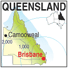 |
Population: 300, Latitude: 19.5500 Longitude: 138.1500 Location: 2,020km north west of Brisbane, 200nw of Mt Isa Highway: Barkly Hwy Nearest Major Town: Mt Isa Nearest Airport: Mt. Isa Touring Area: Outback |
 |
 Camooweal - Courtesy of Tourism Queensland | |
 | ||||
|
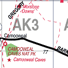
Camooweal is the last Queensland town before crossing the Northern Territory border, 13km.
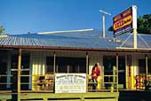
west, and is 188km (120 miles) north west of Mount Isa along the Barkly Highway. When I was last there in 1969 I remember it as mainly a pub, a few shops, and a couple of houses. Two English sisters Carol & Mandy Musgrove attended the bar. (I wonder where they are these days) The pub was the centre of activity and there was usually somebody with a guitar in the bar and singalongs were frequent. Camooweal is a great watering spot on the long journey across from Queensland to Tennant Creek. The next stop west is several hundred kilometres away at the Barkly Homestead, at the turn-off to Borroloola. PLACES OF INTEREST: There are caves in the Camooweal National Park some 25km. south. ACCOMMODATION & SERVICES: 
|


© Copyright Peter W. Wilkins