| COOKTOWN - QUEENSLAND - 4871 | ||||
|---|---|---|---|---|
 |
Population: 1,500, Height above sea level: 15m Latitude: 15.3007 Longitude: 145.1010. Location: 2,050km north of Brisbane Highway: Captain Cook Hwy Nearest Major Town: Cairns 330 south Nearest Airport: Cooktown Touring Area: Tropical North |
 |
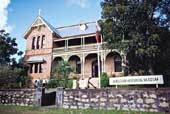 Captain James Cook Museum - Courtesy of Tourism Queensland | |
 | ||||
|
Named after Captain James Cook who discovered the east coast of Australia. In 1770 he beached
his ship 'The Endeavour' here to effect repairs after running aground on a coral reef in the
Great Barrier Reef. Located on the Endeavour River, in was at one stage a boisteous gold mining town and port after gold was discovered at Palmer River and boasted some 37 hotels with a cosmopolitan population of around 20,000 including 6,000 Chinese. Today Cooktown is just a small tropical township with golden beaches and plenty of holiday makers. Care must be taken when swimming at beaches or in rivers at this latitude. The river is a breeding ground for estuarine salt-water crocodiles, and jelly-fish stingers inhabit the ocean during summer and can inflict severe, often deadly stings. The town has several historic buildings, monuments and museums. Nearby are some of the most rugged and vegetated national parks in Australia which comprise the Wet Tropics World Heritage Area. Advice on conditions and travel into these parks should be sought from the National Parks Office before venturing too far. The Cooktown Wharf dates back to the 1880s and is popular for fishing. PLACES OF INTEREST: ACCOMMODATION & SERVICES: 
|


© Copyright Peter W. Wilkins