| EMERALD - QUEENSLAND - 4720 | ||||
|---|---|---|---|---|
 |
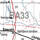
Population: 12,000, Latitude: 23.3005 Longitude: 147.3204 Location: 275 west of Rockhampton, 412 east of Longreach Highway: Capricorn Hwy. Nearest Major Town: Brisbane 920 SE Nearest Airport: Emerald Touring Area: Capricorn - Central Highlands |
 |
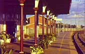 Emerald - Courtesy of Tourism Queensland | |
 | ||||
|
The largest town in the Central Highlands it was established
in 1879 as the construction base for the building of the western railway line. Near sapphire
fields the name comes from the lush green fields surrounding the town - not the emerald gemstone.
Established in 1879 as a service town for construction of the railway from Rockhampton, Emerald has grown into a beautiful city with Morreton Bay Fig trees lining the main street, an attractive and diverse shopping centre and several historic buildings dating back to its early days, although many were destroyed during a series of fires in the town in the middle of last century. At the crossroads of the Gregory and Capricorn Highways, nearby Lake Maraboon offers a variety of water activities and gem fossicking is a popular pastime. The main industries today include coal, cotton, horticultural produce, particularly sunflowers, grain and beef production. PLACES OF INTEREST: ACCOMMODATION & SERVICES: 
|


© Copyright Peter W. Wilkins