 |
Innisfail QLD 4860 |
|---|---|
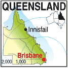
| Population: 9000, Height above sea level: , Latitude: 17.35.00, Longitude: 164.05.00 Location: 1,710km north of Brisbane Highway: Bruce Hwy (1) Nearest Major Town: Innisfail Nearest Airport: Cairns Touring Area: Tropical North | |
|
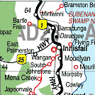
87km south of Cairns on the highway and coast, this town is at the centre of an
area producing much of QueenslandĽs sugar crop.
On the Johnstone River, fishing and boating are popular pastimes. Innisfail was originally called Geraldton but the name was changed to avoid confusion with the town of the same name in Western Australia. | |
 |
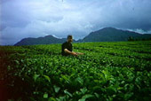 Innisfail Tea Plantation - Courtesy of Tourism Queensland |
| To see a map of the town, click on the top map, for a map of the area, click on the bottom map, for more information about the town, click on the photograph. | |
 |
© Copyright Peter W. Wilkins | |