 |
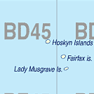
Lady Musgrave Island QLD 4655 |
|---|---|
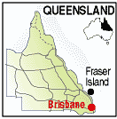
| Population: 100, Height above sea level: Nil, Latitude: 18.25.00, Longitude: 146.15.00 Location: 150km north of Brisbane Highway: Bruce Hwy, Day cruise from Bundaberg Nearest Major Town: Bundaberg Nearest Airport: Bundabergy Touring Area: Fraser Coast | |
| In the southern section of the Great Barrier Reef this small island is surrounded by a reef accessible for swimming or snorkelling. Access to the island is by day cruise from 1770 or Bundaberg, offering spectacular views. Camping with a permit from the Department of the Environment is allowed. Enquiries 1800 072 110 | |
 |
 |
| To see a map of the town, click on the top map, for a map of the area, click on the bottom map, for more information about the town, click on the photograph. | |
 |
© Copyright Peter W. Wilkins | |