 |
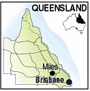
Miles QLD 4415 |
|---|---|
| Population: 1,200, Height above sea level: 302m Latitude: 26.4000 Longitude: 150.1114 Location: 360km north west of Brisbane Highway: Leichhardt (39) & Warrego Hwys (54) Nearest Major Town: Miles Nearest Airport: Roma Touring Area: Toowoomba & Golden West | |
|
North west of Brisbane, Miles preserves its pioneering history in the Miles Historic Village, an
impressive facility with a street of original shops to visit and explore. Lapidary,
artefacts, sea shells and a military display can be seen. Originally named Dogwood Crossing, Miles was established in 1844 along a route Ludwig Leichhardt followed in his many exporations of Queensland and which now bears his name. It is at the centre of a large and diverse rural community and is noted for the wildflower displays which follow spring rains. In September the 'Back to the Bush' celebrations feature wildflowers and colour and should not be missed. Picnic and BBQ facilities are located at Gil Weir on Dogwood Creek and at Morgan Place near the historic village. There are motels and a caravan parks for travellers. | |
 |
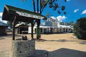 Miles Historic Museum - Courtesy of Tourism Queensland |
| To see a map of the town, click on the top map, for a map of the area, click on the bottom map, for more information about the town, click on the photograph. | |
 |
© Copyright Peter W. Wilkins | |