 |
Oakey QLD 4401 |
|---|---|
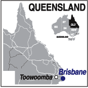
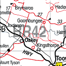
| Population: 4,500, Height above sea level: 406m Latitude: 27.2600 Longitude: 151.4300 Location: 160km west of Brisbane Highway: Warrego Hwy Nearest Major Town: Toowoomba Nearest Airport: Toowoomba Touring Area: Toowoomba & Golden West | |
|
Home of the Australian Military Aircraft Museum. In sugar cane area. Oakey and the creek around which the town is located, were named for the river oaks that dominate the banks of the creek. The area was first settled in the early 1840s when pastoralists moved into the area and found the land to be suitable for grazing. The building of the western railway line through the area prompted the growth of a township to service the pastoral community. Growth of the town was slow, however featured some enterprising ventures, including a short-lived meatworks near the town, which planned to tin and export kangaroo and wallaby under the marketing name 'Australian Game'. The enterprise was unsuccessful and closed down in 1876. | |
 |
 |
| To see a map of the town, click on the top map, for a map of the area, click on the bottom map, for more information about the town, click on the photograph. | |
 |
© Copyright Peter W. Wilkins | |