| PROSERPINE - QUEENSLAND - 4800 | ||||
|---|---|---|---|---|
 |
Population: 4,800, Height above sea level: 15m Latitude: -20.2100 Longitude: 148.3600 Location: 1,100km north of Brisbane Highway: Bruce hwy (1) Nearest Major Town: Proserpine Nearest Airport: Proserpine Touring Area: Whitsundays |
 |
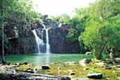 Proserpine - Courtesy of Tourism Queensland | |
 | ||||
|
Proserpine was named for the Roman goddess of Fertility, Proserpina to reflect the rich
and fertile agricultural land which surrounds the town which is the administrative and
service centre for the Whitsunday Shire. At the centre of a massive sugar cane producing area it is also the staging point for visitors to Airlie Beach and the Whitsunday Islands including Hayman, Hamilton, Long and Daydream Islands. Central to national parks and within a short distance of beaches and mountains it offers a variety of activities and attractions including the World Cane Cutting Championships, held each October. PLACES OF INTEREST:
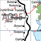
INFORMATION CENTRE: Whitsunday Visitor Information Centre Bruce Hwy, Proserpine. QLD 4800 Ph: 07 4945 3711 HOW TO GET THERE: By car along the Bruce Hwy. between Mackay & Townsville | ||||||||


© Copyright Peter W. Wilkins