 |
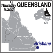
Thursday Island QLD 4875 |
| Population: 2,700, Height above sea level: 58m , Latitude: 10.5810 S Longitude: 142.2190 E Location: 2,800km north of Brisbane Highway: Peninsula Developmental Road, then passenger ferry. Nearest Major Town: Cairns Nearest Airport: Cairns Touring Area: Tropical North | |
|
This remote island 35km north of the northern tip of Cape York, is the main service centre for the
surrounding islands of the Torres Strait. In 1880 Thursday Island was a strategic defence point
for northern Australia and cannons which were to defend against invasion can still be seen.
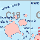
Permit required. Wilkins Tourist Maps Pty Ltd produce an A3 tear-off map of Thursday Island, Horn Island and the Torres Strait. SEE HORN ISLAND | |
 |
 Victoria Parade on Thursday Island |
| To see a map of the town, click on the top map, for a map of the area, click on the bottom map, for more information about the town, click on the photograph. | |
 |
© Copyright Peter W. Wilkins | |