
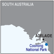
South Australia
The park
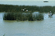
Established in 1966, the 37,000 Ha. Coorong National Park contains a variety of interests for the traveller, including abundant species of birds and wildlife, lagoons, sand-dunes, salt-flats and the magnificent beaches of the Younghusband Peninsula which offer surfing and beach fishing.
The name derives from the aboriginal "Kurangh", meaning "narrow neck", which describes it perfectly. Stretching from near Goolwa to beyond Salt Creek, it varies in width from a few metres to several kilometres. Access to the southern Ocean is via the 42 Mile Crossing at the 130km. marker along the highway.
Made famous as the venue for the 1970's film of Colin Theile's novel "Storm Boy", it has over 400 species of birds and 278 of plants. Plenty of accommodation is available at the motel, caravan parks, cabins and campgrounds, the main centres are at Woods Well, Policeman's Point and Salt Creek.
Camping is permitted at designated locations, and keen fishermen will find Coorong Mullet, Salmon, Flounder, and Mulloway are prolific. Each Australia Day long weekend (Jan 26th) a fishing competition is held on the beach, and for the bush-walker, there are many trails and walks to explore. During school holidays and at Easter, guided tours of approximately 1 to 2 hours are conducted by rangers.
The Coorong Promotions Committee produces an excellent map and guide to the area which is available from most places and the Information Centre is at the National Parks and Wildlife Service office at Meningie.