| CAPE JERVIS - SOUTH AUSTRALIA - 5204 | ||||
|---|---|---|---|---|
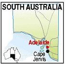 |
Population: 600 Height above sea level: 10m Latitude: 35.36.00 Longitude: 138.06.00 Location: 105km south of Adelaide Highway: Main South Road Nearest Major Town: Adelaide Nearest Airport: Adelaide Touring Area: Fleurieu Peninsula |
 |
 Kangaroo Island Ferry Terminal - Cape Jervis | |
 | ||||
|
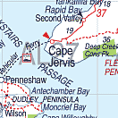
This small town on the south western tip of the Fleurieu Peninsula is the mainland terminus
of the Sea Link Kangaroo Island ferry. Founded on sealing and whaling it achieved more respaectable status through its location as the closest point to Kangaroo island, and the establishment of the ferry there. As a seaport, it also has a fishing fleet and the town services the need of the mariners. Cape Jervis is also the southern starting point of the 1,200km Heysen Walking Trail to the Flinders Ranges. There are spectacular coastal views as you enter the town and Fishery and Morgan's Beaches have excellent fishing. PLACES OF INTEREST: ACCOMMODATION & SERVICES: 
|


© Copyright Peter W. Wilkins