 |
Corny Point SA 5575 |
| Population: 300, Height above sea level: 10m, Latitude: 34.55.00, Longitude: 137.05.00 Location: 260km north west of Adelaide Highway: Off Highway 1 at Port Wakefield Nearest Major Town: Port Pirie Nearest Airport: Adelaide Touring Area: Yorke Peninsula | |
|
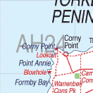
The northern part of the 'toe' on the foot which comprises the Yorke Peninsula. it was named
by Matthew Flinders as he charted and mapped the coast because his charts developed as a leg and foot
shape and this point represented what might be a corn. There is an 1881 lighthouse on the point and the whole region is noted for its surfing, beaches and excellent fishing. Just to the south is the wonderful Innes National Park offering stark scenery, wonderful walks and plenty of photographic opportunites. There are several places to stay at Corny Point or nearby towns and settlements and you can find a list of these using the search engine or listings opposite. | |
 |
 The lighthouse at Corny Point
 |


© Copyright Peter W. Wilkins