| KADINA - SOUTH AUSTRALIA | ||||
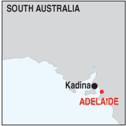 |
Population: 4,000, Height above sea level: 10m Latitude: 33.59.00 Longitude: 137.40.00 Location: 150km north west of Adelaide Highway: Off Highway 1 at Port Wakefield Nearest Major Town: Adelaide Nearest Airport: Adelaide Touring Area: Yorke Peninsula |
 |
 The Currency Museum in Kadina
Download a free A4 map of Kadina. | |
 | ||||
|
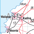
Kadina is located on the Yorke Peninsula, 148 km. north of Adelaide and west
of the National Highway (1) at the centre of the 'Copper Triangle' region. In the 19th. century Cornish settlers moved to the Yorke Peninsula to mine copper from what has become known as the Copper Triangle, comprising the towns of Kadina, Moonta and Wallaroo. copper was discovered in 1859 and was actively mined until 1923. Kadina is the largest town on the Yorke Peninsula and the chief commercial centre for the region. The towns rich history includes the boom copper mining era in the 1800's and early 1900's, explaining it's Cornish culture. Magnificent, historic hotels line the streets including the Royal Exchange, The Kadina and The Wombat Hotels. Take a self guided walking tour of the Wallaroo Mines site or visit the new Visitor Information Centre. The centre serves as an entrance to the Dry Land Farming Interpretive Centre which displays exhibitions that often change so every visit is different. The Cornish, Kernewek Lowender Festival is held in conjunction with Moonta and Wallaroo in May, on odd numbered years. Historical walks, sailing and hiking are among other activities to enjoy while in Kadina. The area is today a rich pastoral land producing grain and other agricultural products and is rich in historical sites related to the mining period. PLACES OF INTEREST: ACCOMMODATION & SERVICES:  ACCOMMODATION & SERVICES:
|


© Copyright Peter W. Wilkins