| KEITH - SOUTH AUSTRALIA | ||||
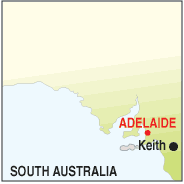 |
Population: 1,200, Height above sea level: 110m Latitude: 36.05.54 Longitude: 140.21.14 Location: 235km east of Adelaide Highway: Dukes Hwy (8) Nearest Major Town: Adelaide Nearest Airport: Adelaide Touring Area: Limestone Coast - Tatiara |
 |
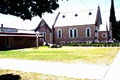 Church and monument at Keith. | |
 | ||||
|
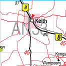
Cross roads to the south east of South Australia and the Tatiara and Wimmera
regions, Keith is a busy grain growing centre and produces around half of Australia's
lucerne crop. It has a significant commercial centre and all facilities including
accommodation and an information centre. The information centre is located in a cafe opposite
an old church with beautiful stained glass windows well worth a photograph.
There are craft shops and art galleries, nearby Mt Monster Conservation Park preserves natural flora & fauna around the granite Mt. Monster, while the Ngarket Conservation Park to the north is some 250,000 Ha. in area. Keith was first surveyed in 1884 and the first permanent building was built in 1896. Keith's water supply is pumped from Tailem Bend, and the pipeline is visible for much of the journey on the southern side of the highway. Acoss the railway line you can see an old settlers house and there is a Land Rover mounted high on a pole in a park along the highway. 24 hour petrol and food is available from a roadhouse and there are hotels, motels, and a caravan park. PLACES OF INTEREST:
INFORMATION CENTRE: Some information is available from the cafe opposite old church and park near the highway. There is an information centre in Bordertown Bordertown Visitor Information centre 81 North Tce, Bordertown. SA 5268 Ph: 08 8752 0700 HOW TO GET THERE: By car along the Dukes/Western Hwy. (8) | ||||||||


© Copyright Peter W. Wilkins