| NAIRNE - SOUTH AUSTRALIA - 5252 | ||||
|---|---|---|---|---|
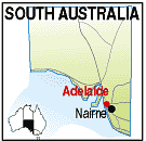 |
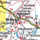
Population:2,000, Latitude: 35.0200 Longitude: 138.5500 Location: 40km east of Adelaide Highway: South Eastern Fwy Nearest Major Town: Adelaide Nearest Airport: Adelaide Touring Area: Adelaide Hills |
 |
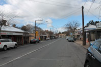 Main street of Nairne in the Adelaide Hills. | |
 | ||||
|
A short journey from Hahndorf towards Murray Bridge, the rural township
of Nairne was established in 1839 by Scotsman Matthew Smillie and named for
his wife's maiden name, Elizabeth Nairne.
His original acquisition of 4,000 acres was subdivided into 80 acre lots for wheat farming, with provision for the township, a school, church, etc. and was offered for sale. Like Mount Barker, flour mills needed to be established before the land created much interest, and one of the mills, Albert Mill, just off the main street, still remains. There are many buildings of historic interest remaining, including the old Police Station, the Catholic Church, the Miller's Arms Hotel, the railway station, and the Institute. A brochure is available locally or at the Hills Information centre in Hahndorf. PLACES OF INTEREST: ACCOMMODATION & SERVICES: 
|


© Copyright Peter W. Wilkins