| WALLAROO - SOUTH AUSTRALIA - 5556 | ||||
|---|---|---|---|---|
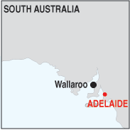 |
Population: 2,750, Height above sea level: 20m Latitude: 33.5500 Longitude: 137.3500 Location: 160km north west of Adelaide Highway: Off Highway 1 at Port Augusta Nearest Major Town: Adelaide Nearest Airport: Adelaide Touring Area: Yorke Peninsula |
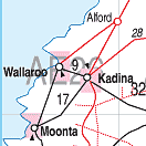 |
 The Maritime Museum in Wallaroo. Download a free A4 map of Wallaroo. | |
 | ||||
|
In 1859 copper was discovered on the Yorke Peninsula and during the life of
the mines around the area of Kadina and Wallaroo high yields of up to 30% copper
were extracted from the rich ore. Production ceased in the 1920's and many relics
of the mining days remained as the area turned to primary production. Today
the area around Wallaroo produces grain and meat products, and there is a fertilizer
company employing a large number of locals.
The name Wallaroo came from the aboriginal 'Wadlu Waru', meaning 'wallaby's urine'. The early settlers imitated this in Wall Waroo, and it was eventually shortened to Wallaroo. Guided tours of the towns copper history and historic buildings are conducted with guides from the Wallaroo Museum. PLACES OF INTEREST: A National Trust Museum depicting Wallaroo's history in displays of copper smelting, postal, and municipal history. A maritime section outlines the history of the port. The building was built in 1865. ACCOMMODATION & SERVICES: 
|


© Copyright Peter W. Wilkins