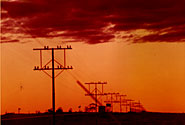
The 514km. Birdsville Track is one of Australia's best known Outback adventures.The unsealed track goes from Marree in South Australia's mid-north, to Birdsvillein the south-western corner of Queensland through some of Australia's driestcountry.
Starkly beautiful and challenging for car and driver, the track passesbetween the Simpson and Sturt's Stony Deserts, past Lake Eyre, and west of theInnamincka Regional Reserve.
Most of the track is through the Strzelecki Desert and those wishing todo the trip must take adequate provisions of water, food, petrol and basic spareparts like spare fan-belts, radiator hoses, spark plugs and other parts whichmight seem unnecessary at the time, but can be invaluable if you are stuck hundredsof kilometres from the nearest service station. An additional spare tyre isalso recommended.
The track used to be only accessible to 4 wheel drive vehicles, but recentlyit has been maintained to a degree where most vehicles can travel along it.These days the road is frequently graded to provide reasonable surfaces fortravellers and the many beef cattle transport trucks which use it. As with mostoutback regions of Australia, the road can be cut suddenly by heavy rains whichfall from time to time and cause usually dry rivers to flash flood. This cansometimes result in being stranded between rivers for up to a week so adequatesupplies of food and water should be taken as a precaution Corrugations formon all outback road surfaces and will sometimes make the trip uncomfortable,not to mention, unsafe. You will discover a speed which is safe and comfortableon most roads.
If you are planning to do this adventurous journey you can obtain up to theminute information on conditions from the Northern Area Road Condition Hotline on 1300 361 033
MARREE: (647Km. North of Adelaide)
Once known as Hergott Springs it was the staging post for camel trains whichtransported goods from the railhead to the outback and Alice Springs. For 20years until 1980 it was a major break-of-guage station on the "Ghan"rail journey to Alice Springs but the new rail now runs some 200 kilometreswest.
It is now a small service centre for surrounding stations and travellersalong the Birdsville and Oodnadatta Tracks. there is an hotel, caravan park,general stores, post office, take-away food outlets, hospital and police station.A weekly bus service operates to Marree.
A picnic race meeting and Gymkhana is held each June. LAKE HARRY:
Around 30km. north of Marree the government struckits first bore for the stock route. The deserted homestead was occupied until1951 and was a busy camel trading post. In the 1860's some 200 date palmswere planted experimentally at Lake Harry. Baron von Mueller, a noted earlybotanist, theorised that date palms would provide a food and shade source aroundoutback waterholes and palms were planted at many remote waterholes. Lake Harrycan be seen to the east of the road. THE DOGFENCE:
A little further north you will pass the dogfence which stretches from the New South Wales border to the Great AustralianBight near Streaky Bay, a distance of over 9,600 kilometres. The fence was builtin an attempt to keep marauding dingos from the sheep flocks grazing to itssouth. CLAYTON RIVER:
Crossed at the turn-off to Clayton Station DULKANINNA:
Established in the late 1800's, Dulkaninna Stationis near the Dulkaninna Creek, fed by an artesian bore. CANNUWAUKANINNA BORE:
This bore exudes water so hot it travels nearlya kilometre before it is cool enough for stock to drink. West of the bore, theLake Palankarinna Fossil Reserve on the edge of the Tirari Desert provides valuablescientific information about early life in Australia. ETADUNNA HOMESTEAD:
A memorial beside the track remembers the effortsof Lutheran missionaries who ran the aboriginal settlemant at Killalpaninna,the ruins of which are approximately 20km. north of the station. It was builtin 1866 and provided for some 200 aboriginals until its close after the severedrought of 1915. COOPER CROSSING:
203 Km. north of Marree is the Cooper Creek Crossingand the turn off to the 'flood' road and ferry. When this massiveriver is in flood the ferry is used in daylight hours only and provides accessacross the river for cars and attached trailers providing the wheels are containedwithin the safety chains of the ferry. Caravans are not allowed. Informationon the ferry service is available by telephone on (086) 48 5211.
The old barge which provided the crossing from 1949 to 1956, the 'Tom Brennan' , is restored and on display at the Cooper Crossing.
Usually the 10km. crossing is dry. NATTERANIE SANDHILLS:
These sandhills average 9 metres in height andstretch from the western side of the road to the Simpson Desert. The 'flood'road rejoins the track just north of the normal crossing and these sandhillswere the most difficult and notorious part of the track in its early days. MULKA HOMESTEAD:
Just south of the new Mulka Homestead the ruins ofMulka Store can be seen 1km. west of the track. It was established in 1883 byAlexander Scobie. OOROOWILANNIE RUINS:
The ruins of the homestead are just north ofthe Ooroowilannie Swamp. MUNGERANNIE ROADHOUSE: (850km. from Adelaide)
The roadhouse is adjacent to the Mungerannie Homestead, 204km. north of Marreeand 313 south of Birdsville, on the Derwent Creek. It provides fuel, food, accommodation,emergency repairs and camping and is the only service area along the track. COWARIE & KALAMURINA HOMESTEADSTURN-OFF:
Leads to the homesteads (Cowarie 49km:Kalamurina 58km.) on the edge of theSimpson Desert MUNGERANNIEGAP:
The highest point on the road (1500m.) the track descends 3km. to MungerannieGap GYPSUMCLIFFS:
Just north of the Kirrawadinna Creek gypsum deposits can be seen just eastof the track. MITTA MITTABORE:
Hot water gushes to the surface from this bore and runs hundreds of kilometresbefore cooling sufficently to use. LAKE HOWITT:
A dry saltpan west of the track and north of Mitta MittaBore. MT. GASON BORE:
An artesian bore about 2 km. from the track to thewest.
SIMPSON DESERT TURNOFF: 11 km. south of Clifton Hills the turn-off to the K1 Line track overthe Simpson Desert, which connect with Rig Road. (See Map) Another route leadsacross the north-west edge of Goyders Lagoon and on to Birdsville. WARNING: Do not attempt to use these routes unless equipped with 4WD vehicle, deatiledmaps and adequate supplies and preparation. A Desert Parks Permit is requiredif entering the Conservation Park or Regional Reserve. CLIFTON HILLS HOMESTEAD AND GOYDERS LAGOON: The original route through Goyders Lagoon from Clifton Hills is now closedand impassable. the longer 'outside track' which passes through 'gibbercountry' (rocks) on the edge of Sturt's Stony Desert is now the main route.
BIRDSVILLE: (Adelaide 1161 Km.)
Located 12km. into Queensland, it originated around a store built in 1882to cater to drovers using the stock route. Until Federation in 1901 it was acustoms town for interstate trade and is now little more than a pub and missionhospital. Facilities include an hotel/motel, caravan park, general store, postoffice agency, garage and a sealed runway airport for light planes. If you aretravelling in a large organised group it is wise to notify ahead of requirementswhich must be brought in from other areas, including food.
Birdsville is famous for its Birdsville Race Meeting held in Septembereach year and attracting people from all over the country. Truckloads of refreshmentsare brought in and the airstrip is gets plenty of use with planes from remoteareas parked everywhere. If you are attending thenraces make sure you have plentyof provisions and good camping equipment. INFORMATION
Information in this section was compiled from personal experienceand from the Flinders Ranges & Outback of South Australia Regional Tourist Associationexcellent Outback publication 'Flinders Ranges and Outback'. P.W.
Further enquiries to P.O. Box 41. Port Augusta, South Australia 5700. Ph:08 8642 2469: Fax: 08 8642 0781.