 AUSTRALIA STRIP MAP SERIES
ADELAIDE TO CEDUNA: The Eyre Highway (1)
|
|
AUSTRALIA STRIP MAP SERIES ADELAIDE TO CEDUNA: The Eyre Highway (1) |
|---|---|
|
| |
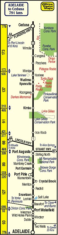 |
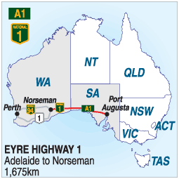
ADELAIDE TO PERTH Via The Eyre Highway (1) The Eyre Highway begins at Port Augusta and leads across the Nullarbor Plain to Norseman, where it divides to enter Perth via Coolgardie, to the north, or Albany (1) to the south. It is a long and arduous trip across the Nullarbor Desert and, although there are plenty of roadhouses and a few small towns along the way, the 3,000 kilometre journey will take several days for the average driver. Despite this, there are some fascinating things to see. Underground caves at Cocklebiddy, spectacular coastline just a short detour south of the highway in many places, and fantastic sunsets and sunrises will be seen. The following summary of the road includes general information and links to some of the towns and attractions along the way CEDUNA Ceduna is the western most major centre in South Australia and is a fishing and touring centre for the Nullabor Plain. From the nearby cliff tops overlooking the Great Australian Bight, whale watching between May and September is a popular pastime. THE EYRE PENINSULA The Eyre Peninsula is a vast region of South Australia offering national parks, historic buildings, spectacular coastline and beaches, and is a popular alternative way to reach Ceduna before the Nullarbor Crossing. THE FLINDERS RANGES the Flinders Ranges stretch from north of Port Augusta to South of Crystal Brook. There is some spectacular scenery and plenty of quiet shady places to stop and have a picnic. PORT AUGUSTA: Port Augusta is one of South Australia's busiest towns. It is the highway and railway crossroads for Australia and was once considered as being the site for a national capital instead of Canberra. 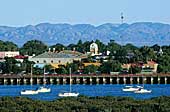 PORT PIRIE: Port Pirie is a mineral producing town on the gulf and is a short detour west of the highway. There is plenty of accommodation and things to do. 
PORT WAKEFIELD: |

|
© Copyright Peter W. Wilkins |