|
|

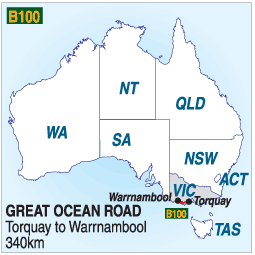
THE GREAT OCEAN ROAD
NB: The numbers down the left side of the maps are taken from the numbers on marker posts each
kilometre along the southern side of the road and are the distance from Melbourne.
The Great Ocean Road is one of Australia's premier tourist drives. Forests, golden beaches, surf
and spectacular coastal formations are all seen as you travel between the quaint villages which
line the coast between the Otway Ranges and the sea. See main story for full details.
The following summary of the road includes general information and links to these towns and
attractions.
TORQUAY:
Capital of the Surf Coast and the first place you meet the water from Geelong. Noted for its beaches
and surfing shops there is a Surf Museum. Motels, caravan parks, restaurants.
LORNE:
Lorne is the principal town along the Great Ocean Road and nestles into Loutitt Bay with a curved beach
into which the Erskine River flows. In the ranges behind the town the Erskine Falls are a
popular destination, and the main street is lined with cafes, restaurants, takeaway food shops
and boutique shops providing just about anything you could want.
The 'Pub to Pier' swim is a favourite annual event held in January and attracts thousands to swim the
kilometre or so between the two landmarks. There is plenty of varied accommodation, some of which will
be found in these pages, and Lorne is only a 2 hour drive from Melbourne which makes it a popular
weekend destination.
APOLLO BAY:
Apollo Bay is the second largest town along the road and is at the eastern end of the Otway Forest
Park and close to rainforest walks and Cape Otway. Motels, caravan parks, shopping centre, beach,
pier and an airstrip between Apollo bay and Marengo
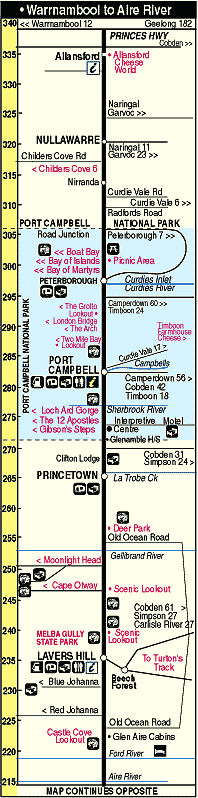
PRINCETOWN:
Princetown is a small settlement between Lavers Hill and Port Campbell with some accommodation,
a bistro/restaurant, and a nearby deer farm. It is near the eastern end of the Port Campbell
National Park
PORT CAMPBELL:
Port Campbell is at the centre of the national park which bears its name and features the
famed 12 apostles and many other natural features. There is plenty of accommodation, restaurants
and takeaways, and an historic museum. A fishing fleet will usually be seen in the pretty
natural harbour.
PETERBOROUGH:
Peterbourough is located on the Curdies Inlet where it meets Bass Strait and has a colourful
maritime history. At the western end of the Port Campbell National Park it is central to
many of the main attractions of the park. Motels, caravan park, hotel, general store.
MELBA GULLY:
The Melba Gully is a rainforest area just west of Lavers Hill which takes its name from diva
Dame Nellie Melba. A rainforest walk is a rewarding experience and there are glow-worm
tours of a night. Motel, tea rooms, restaurant, hotel.
MAITS REST:
The Maits Rest Forest Walk is one of the newer additions to the many attractions of the Great
Ocean Road and is located some 20km west of Apollo Bay between it and the Cape Otway turn-off.
CAPE OTWAY:
The Cape Otway light is now automated and the existing buildings have been turned into an
accommodation centre for visitors to the light and the Otway Park.
|
|
|
 AUSTRALIA STRIP MAP SERIES
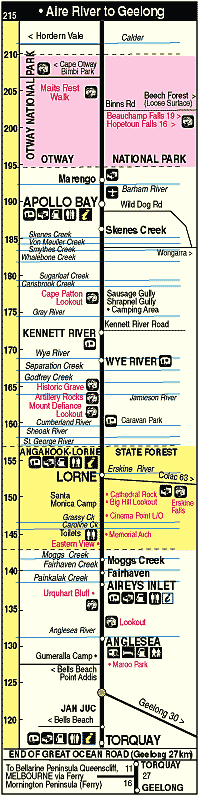
 © Copyright Peter W. Wilkins