 AUSTRALIA STRIP MAP SERIES
ALICE SPRINGS TO ELLIOT: The Stuart Highway (87)

|
 AUSTRALIA STRIP MAP SERIES
ALICE SPRINGS TO ELLIOT: The Stuart Highway (87) |
|---|---|
|
| |
Joins Elliot to Darwin map Adelaide to Alice Springs Map Tennant Creek to Townsville Map |
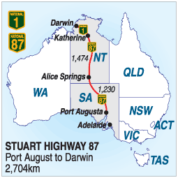
ALICE SPRINGS TO ELLIOT: - Via The Stuart Highway The road between Alice Springs and Darwin travels through some of the harshest country in the world. The highway was bitumised during World War Two and is now a modern and comfortable road with stops every 1 or 200 km. to ease the 1500 km. journey. It passes through the Devils Marbles Conservation Park near Wauchope, the Katherine Gorge and Mataranka Springs, and near Darwin the Arnhem Highway will take you to the World Heritage Area at Kakadu. Along the way you will see extensive desert areas, rugged ranges, a few mountains, and there are waterfalls and rivers. Be careful swimming in the northern rivers as man-eating crocodiles frequent many rivers and estuaries. There is no speed limit on highways in the Northern Territory but it is wise to travel at a speed at which you can stop quickly. Large tracts are unfenced and wandering cattle and other animals can appear at any time The following summary of the road includes general information and links to some of the towns and attractions along the way ELLIOT: Elliot is around half way to Darwin and is a small town with an hotel and a caravan park. Limited accommodation is available in small units at the hotel. A visit to nearby Lake Woods is well worthwhile. Just north, Newcastle Waters was once a major hazard on the road, holding up traffic for several days and sometimes weeks, after heavy rain. A bridge built in the 1980s now solves this problem Newcastle Waters Station off to the west is owned by PBL which was headed by the late Kerry Packer. RENNER SPRINGS: Renner Springs is a roadhouse on the highway between Tennant Creek and Elliot. THREE WAYS: Three Ways is the junction of the Barkly highway from Mount Isa and Queensland and the Stuart Highway. There is a pub, a roadhouse, an impressive monument to John Flynn, and off to the west are the 'Devil's Pebbles', a miniature version of the Devils Marbles. TENNANT CREEK: Tennant Creek is one of the Territory's largest towns and is a tourism and mining centre straddling the highway. There are motels, caravan parks, pubs and plenty of shops. THE DEVILS MARBLES: Giant rocks scattered on both sides of the highway just north of Wauchope are a photographers delight. Time and erosion has worn away the surrounding soil leaving the granite rock exposed, and wind and rain has shaped them into giant balls. You can't miss them, but get your camera ready. WAUCHOPE: A popular pub and roadhouse along the way. Inside you will find some fascinating bits of Territory memorabilia. WYCLIFFE WELL: Another roadhouse just south of Wauchope. ('The more the better'). BARROW CREEK: This was the scene of a sneak attack by local aborigines on staff at the Telegraph Station in which 2 men died. They are buried in graves near the historic telegraph station. There is a pub and petrol and basic mechanical services are available. It was to Barrow Creek that English tourist Joanna Lees reported the ambush of their vehicle and the disappearance of her partner Peter Falconio. TI TREE: This small town is now a large producer of fresh vegetables and fruit for Territory markets. There is a school, a pub with cabin accommodation and a general store. It is the largest community between Alice Springs and Tennant Creek. AILERON: Aileron is a small hotel and general store north of Alice Springs. PLENTY HIGHWAY: This mainly loose surface road services many stations outback stations and eventually leads in to Mount Isa in Queensland. It is a more direct route for travellers to Queensland who don't mind a bit of dirt and outback. ALICE SPRINGS: The legendary town of Outback Australia. Gateway to Ayers Rock, and set among the beautiful MacDonnell Ranges on the Todd River. |
 © Copyright Peter W. Wilkins
 | |