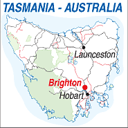
Elevation: 10m
Latitude:42.4200
Longitude:147.1600
Location: 27km north of Hobart
Highway:Old Midland Hwy (1).
Nearest Major Town:Hobart
Nearest Airport:Hobart
Touring Area:Heritage Area

| BRIGHTON - TASMANIA - 7030 | ||||
|
|
Population: , Elevation: 10m Latitude:42.4200 Longitude:147.1600 Location: 27km north of Hobart Highway:Old Midland Hwy (1). Nearest Major Town:Hobart Nearest Airport:Hobart Touring Area:Heritage Area |
|
| |
| ||||
|
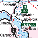
Situated 27 km north of Hobart the township of Brighton has been a military post since
it's establishment in 1826. The Brighton Army Camp is Tasmania's main military post. Brighton offers varied accommodation and plenty to do including a popular wildlife park housing Tasmanian native animals, including Tasmanian Devils. Only a half hour drive from Hobart it is an enjoyable stop on a round tour of the Derwent Valley. Nearby Pontville has many classified historic buildings. Pontville recently was used as a detention centre for immigrants arriving by boat from, mainly Indonesia, without proper authority and claiming refugee status. Brighton was a popular stop along the Midland Highway but in 2013 the old highway was by-passed and through visitors have declined. There is an hotel, takeway food, a post office and several shops. The turn off to Bonorong Wildlife Park and ZooDoo will be found at the southern end of the main road. PLACES OF INTEREST:
INFORMATION CENTRE: Tasmanian Visitor Information Centre Cnr. Davey & Elizabeth Sts., Hobart, TAS. 7000 Telephone: 03 6230 8233 HOW TO GET THERE: From Launceston Take the Midland Hwy south through Campbell Town. From Hobart Take the Midland Hwy north through Bridgewater. TOURS: Coach Operators Redline: Ph: 1300 360 000 Greyhound Pioneer: 132 030 | ||||||||

 |
© Copyright Peter W. Wilkins | |