| CRESSY - TASMANIA - 7302 | ||||
 | ||||
 The 'Big Trout' in the main street of Cressy. |
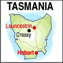 |
Population: 250, Elevation: 30m Latitude: -41.4200 Longitude: 147.0500 Location: South of Longford in the north Highway: Off Midland or Bass Hwys Nearest Major Town: Launceston Nearest Airport: Launceston Touring Area: Heritage Area |
 |
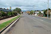 Main street of Cressy. |
|
Cressy boasts one of Australia's 'Big Things' and you can see the 'Big Trout' beside the
main road in a park south of the few main shops and hotel. Cressy is a popular freshwater
fishing rendezvous area for the lakes district to the west via Poatina.
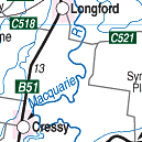
It is located south of Longford in the Norfolk Plain area where the small township of Cressy
was established in the 1850s and is a prolific agricultural production region
producing peas, beans, oats, barley and opium poppies. Nearby at Longford is the Brickendon Historic Farming Village and Gardens surrounded by 170 year old trees with over 100 species of roses. The gardens are National Heritage listed and the village reflects convict times of early settlement. There is a back road leading to Campbell Town on the Midland (Heritage) Highway, saving the round trip back through Longford and Perth. You could also take the road through Poatina and Miena and join the Lyell Hwy at Bronte Park and continue on to the west coast. Accommodation is available at the Ringwood Hotel-Motel in the town centre.
INFORMATION CENTRE: Information is available from the Gallery in Marlborough St. HOW TO GET THERE: Off the Midland Hwy from Perth via Longford or from Powranna, south of Perth. Light Plane | Coach Coach Operators Redline: Ph: 1300 360 000 Greyhound Pioneer: 132 030 | |||||||||

 |
© Copyright Peter W. Wilkins | |