| KETTERING - TASMANIA - 7155 | ||||
 | ||||
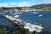 The harbour and town of Kettering. |
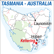 |
Population: 300 Elevation: 15m Latitude: -43.0800 Longitude: 147.1500 Location: 34km south of Hobart Highway: Channel Hwy. Nearest Major Town: Kingston Nearest Airport: Hobart Touring Area: The Channel |
 |
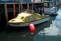 Hire a boat and explore the harbour. |
|
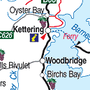
Located 34km from Hobart on the Channel Highway the township of Kettering is an important fruit
growing area. Access to Bruny Island is gained by the busy ferry terminal in Kettering,
which makes up to 9 crossing daily between Kettering and Roberts Point. You can purchase
tickets at the Information Centre - Kiosk at the terminal. The pretty and safe harbour is a delight and you can explore it in a runabout hired from Channel Hire Boats from the Oyster Cove Marina. The office and shop also contains an extensive range of equipment and accessories for boats and yachts. The harbour at Kettering is picture postcard perfect with great photgraphic opportunities from most angles. There is an hotel and a camping ground at Gordon (19km south). | ||||||||
| >
PLACES OF INTEREST: |
INFORMATION CENTRE: Bruny D'Entrecasteaux Visitor Information Centre 81 Ferry Road, Kettering, TAS. 7155 Telephone: 03 6267 4494 HOW TO GET THERE: From Hobart Take the Channel Hwy (B68) south via Kingston to Kettering. Coach Operators Redline: Ph: 1300 360 000 Greyhound Pioneer: 132 030 | ||||||||

 |
© Copyright Peter W. Wilkins | |