 |
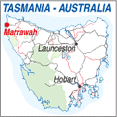
Marrawah TAS 7321 |
|---|---|
|
Population: 100, Elevation: 25m Latitude: Longitude: Location: 65km south west of Smithton Highway:Bass Hwy. (A2) Nearest Major Town:Smithton Nearest Airport:Wynyard Touring Area:The North West | |
|
Located 65km south west of Smithton near Stanley this small rural centre is
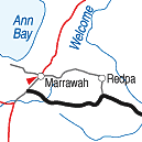
reached along the bitumen road through rolling dairy and sheep pastures with occasional forest. Along the way the Dismal Swamp is a forestry centre set up on the south side of the road and there is an hotel and a few houses at Marrawah. From Marrawah a bitumen road continues south to Arthur River then a loose surface road continues to Zeehan crossing the Pieman River at Corinna by punt. | |
 |
 The tiny township of Marrawah. |
| Some towns have more detail, for more information about the town, click on the photograph. | |
 © Copyright Wilkins Tourist Maps Pty Ltd |