| MOLE CREEK - TASMANIA - 7304 | ||||
 | ||||
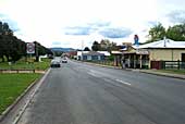 Main street of Mole Creek |
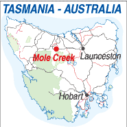 |
Population: 250 Elevation: 250m Latitude: -41.3322 Longitude: 146.2405 Location:50km west of Deloraine or south of Devonport. Highway: Meander Valley Hwy Nearest Major Town: Devonport Nearest Airport: Devonport Touring Area: Great Western Tiers |
 |
 Giant Tasmanian Devil at the entrance to Trowunna Wildlife Park. |
|
Small town south west of Launceston near Cradle Mountain. Shopping and services.
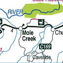
Accommodation. Nearby Mole Creek-Kartz National Park and King Solomon's Caves. Mole Creek is a small settlement in the shade of the Great Western Tiers and at the heart of a large farming, dairy and forestry area. It mostly comprises the main street which has a hotel, craft shop, supermarket and a couple of takeaway food shops. Petrol is available just off the main road and there is a school and other essential services. Towards the eastern end of the town there is a honey factory producing local honey and the Trowunna Wildlife Park is further east of the town. The Nearby Marakoopa and King Solomon Caves are west of Mole Creek and well worth visiting. They are open to the public and managed by National Parks.
INFORMATION CENTRE: Great Western Tiers Visitor Centre Emu Bay Rd, Deloraine. Tasmania. 7304 Local information is available at the hotel and Wilkins Tourist Maps produce a free touring map of the area. HOW TO GET THERE: Coach Operators Redline: Ph: 1300 360 000 Greyhound Pioneer: 132 030 | |||||||||

 |
© Copyright Peter W. Wilkins | |