| PENGUIN - TASMANIA - 7316 | ||||
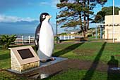 The big penguin on the foreshore at Penguin. |
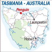 |
Population: 2,910, Elevation: 10m Latitude: -41.07.40, Longitude:146.04.22 Location: 300km north west of Hobart Highway:Bass Hwy Nearest Major Town: Ulverstone Nearest Airport: Devonport Touring Area: Cradle Gateway |
 |
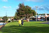 Main street of Penguin. |

|
Named by botanist Ronald Gunn after the fairy penguins, which are still evident in rookeries along the
coast, Penguin is one of the main north-west coast residential centres. With the Dial Range in its background.
the area boasts some breathtaking scenery and a fine beach and is
a prime production area for vegetables for local and interstate markets. The Penguin area was first settled in 1861 by Edward Beecroft, and became a municipality in 1908 with an area of 43,185 Ha. The Big Penguin on the foreshore was erected to celebrate the centenary of the proclamation of the town on the 25th. October, 1975 when the population of Penguin reached 3,000. What to see and do: Penguin rookery tours (November-March), Mt Montgomery and Dial Range (4km), Ferndene Gorge Reserve (6km), Gunns Plains Caves, via Riana, and scenic drive to Ulverstone via coast road, passing islands named the Three Sisters (12km), ostrich farms and Pindari Deer Farm.
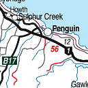
INFORMATION CENTRE: Penguin Visitor Information Centre 78 Main St. Penguin. TAS 7316 Ph: 03 6437 1421 HOW TO GET THERE: The Spirit of Tasmania Ferry operates to Devonport and there is an airport at Devonport and to the west at Wynyard, both have direct flights to and from Melbourne. Coach Operators Redline: Ph: 1300 360 000 Greyhound Pioneer: 132 030 | |||||||||

 |
© Copyright Peter W. Wilkins | |