| QUEENSTOWN - TASMANIA - 7467 | ||||
 | ||||
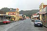 Main street of Queenstown |
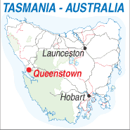 |
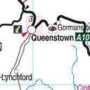
Population: 2,352 Elevation: 145m Latitude: -42.0449 Longitude:145.3325 Location:258km north west of Hobart Highway: Lyell Hwy Nearest Major Town: Queenstown Nearest Airport: Queenstown Touring Area: West Coast |
 |
 |
|
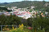
The Classified Historic Town of Queenstown has seen over 100 years of mining of the Mt
Lyell copper deposits. The bare hills of Queenstown have remained that way since
1900 when they were stripped by elements and sulphur. Regrowth is beginning to reclaim the 'moonscape' hills around Queenstown that resulted from the combination of rain, mining, timber cutting and bushfires. Nevertheless, Queenstown - the 'capital' of the west, still has a distinctive character. Mining has been the mainstay for more than a century, with displays from the past and tours of present mine operations being essential for visitors wanting to gain an appreciation of the colourful, historical town. What to see and Do: Tours of Mt Lyell Company surface mine operations and the company's museum, Queenstown photographic collection in the Old Imperial Hotel, Miners Siding and, farther afield, the Franklin-Gordon Wild Rivers National Park, which is part of the World Heritage Area and can be accessed from the Lyell Highway about 50km east of Queenstown. Gallery Museum, Lake Burbury and Nelson Falls. The West Coast abt railway runs between Strahan and Queenstown and is a wonderful journey on an unique trafin through the rainforest.
INFORMATION CENTRE: Royal Automobile Club of Tasmania Office Orr St. Queenstown. 7467. Tasmania Ph: 03 5465 3767 HOW TO GET THERE: Coach Operators Redline: Ph: 1300 360 000 Greyhound Pioneer: 132 030 90 minute tours available daily from the Lyell Tours at 1 Driffield St. Enquiries 03 6471 2222 Organising boating and fishing tours on Lake Burbury. Ph 03 6471 1888 4WD Tours to various destinations including Mt McCall, Pieman River, Montezuma Falls, Lake Margaret and many more. Ph 03 6471 2222 for information. | |||||||||

 |
© Copyright Peter W. Wilkins | |