| SORELL - TASMANIA - 7172 | ||||

| ||||
 |
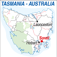 |
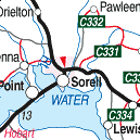
Population: 3,200 Elevation: 14m Latitude: -42.4659 Longitude:147.33.45 Location: 26km east of Hobart Highway:Arthur A9 and Tasman A3 Hwys Nearest Major Town: Hobart Nearest Airport: Hobart Touring Area: Hobart Area |
 |
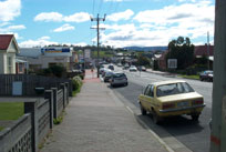
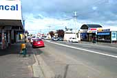 Main shopping centre in Sorell. |
|
Sorell is the largest city east of Hobart and the administrative centre for an area extending
south west to Eaglehawk Neck. It was named after Lieutenant Governor Sorell in 1821 when the
district was known as Pittwater and this honour encouraged Sorell to take an active interest in its
welfare and growth, it is said he even considered moving the capital to Sorell at one stage. The causeway which connects Cambridge with Sorell via Midway Point was built in 1866 and meant access to the town was more direct. Until then travellers had to pass through Richmond, to the north, to get to Sorell. In 1892 a rail link was opened with Hobart but it closed in 1926. A large grain producing district, from 1816 to 1860 it provided grain for Tasmania and, for 20 years, also for New South Wales. Sorell offers visitors an array of interesting activities from fishing and golf to exploring the museum, market, antique shops, fruit farm, and vineyards. Sorell is also an important cross-roads for visitors to Port Arthur and the Tasman Peninsula, or to the east coast. An information centre will be found in the centre of town and Wilkins Tourist Maps produce a free map, issued locally.
INFORMATION CENTRE: Sorell Visitor Information Centre 16 Gordon st. Sorell. TAS 7172 Ph: 03 6265 6438 HOW TO GET THERE: Coach Operators Redline: Ph: 1300 360 000 Greyhound Pioneer: 132 030 | |||||||||

 |
© Copyright Peter W. Wilkins | |