| STANLEY - TASMANIA - 7331 | ||||
 | ||||
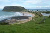 'The Nut' overlooking Stanley |
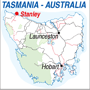 |
Population: 583 Elevation: 10m Latitude: -40.4530 Longitude: 145.17.23 Location: 410km north west of Hobart Highway: Bass Hwy. Nearest Major Town: Burnie Nearest Airport: Wynyard Touring Area: North West |
 |
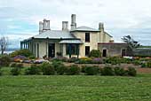 Highfield - Historic Site |
|
Beachside town in north western Tasmania Offering river cruises, beaches, waterfalls,
forests and reserves. Plenty of accommodation. Noted for the rocky headland ‘The Nut'
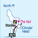
which creates a spectacular backdrop to the town. Stanley is living history - even the cemetery is interesting! It contains the graves of colonial architect John Lee Archer and surveyor Henry Hellyer, who were among the pioneers that left their mark in this classified historic town. Nestled at the base of 'The Nut', a 150 metre-high rocky outcrop named by explorers George Bass and Matthew Flinders, Stanley has a wealth of 19th and early 20th century buildings, many of which have been turned into visitor attractions and accommodation. What to see and Do: Take time to walk around the town, call at the Plough Inn, Lyon's Cottage (the birthplace of Prime Minister and Tasmanian Premier Joseph Lyons) and the Discovery Centre, travel by chairlift or walk to the summit of The Nut, view fish processing or wander round the nearby Highfield Estate, established in 1826 as the headquarters of the Van Dieman's Land Company, which was responsible for the early development of Stanley. Fresh crayfish can be purchased here and eaten.
INFORMATION CENTRE: Stanley Visitor Information Centre 45 Main St. Stanley. Tas. 7331 HOW TO GET THERE: Coach Operators Redline: Ph: 1300 360 000 Greyhound Pioneer: 132 030 | |||||||||

 |
© Copyright Peter W. Wilkins | |