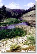
The beautiful Tambo River
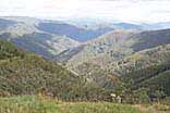
Alpine view near Mt Hotham
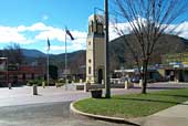
Central Square in Bright

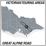
GREAT ALPINE ROAD
The Great Alpine Road is a spectacular drive across the Alpine Country of northern Victoria
between Bairnsdale in the east and Wangaratta in the north. The road passes through the ski
resort of Mt Hotham and the alpine town of Dinner Plain near the highest point and is only
accessible to vehicles with chains fitted during the winter months. National Park rangers inspect
all vehicles entering the park at these times.
The section of road between Bruthen and Swifts Creek closely follows the Tambo River on the east
and winds around the lower region of the high country through small villages until it reaches the junction
of the Omeo Hwy rear Omeo. This road also leads over the alps to Tallangatta on the Murray Valley Hwy. There is
some loose surface along the way.
From Omeo the road begins to climb quite steeply past Cobungra Station and into Dinner Plain. A little further
on Mt Hotham is the apex of the road and the descent begins into Harrietville and Bright then on to Wangaratta
to join the Hume Hwy south to Melbourne.
In summer there is much to see along the road. Wildflowers are prolific in September/October, there are many
spots with panoramic views over the alps and ideal for photographs, and there are several walking trails.
A rail-trail bike track between Wangaratta and Bright along the Ovens Valley is an attraction for the adventurous
and there are many things to see and do in both the Ovens Valley and Tambo valley.
This is a worthwhile detour and a wondertful way to spend a couple of days exploring the Alpine High Country.
A suggested round trip is marked in orange on the touring map.
Select an area from below to automatically open it on this page.
Click on a town to open it
TOWNS ON THIS MAP


© Copyright Peter W. Wilkins