| BRIGHT - VICTORIA - 3741 | ||||
|---|---|---|---|---|
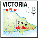 |
Population: 2,080, Elevation: 318, Latitude: -36.4373 Longitude: 146.5686 Location: 310km north of Melbourne Highway: Great Alpine Road Nearest Major Town: Albury Nearest Airport: Albury Touring Area: Legends Wine & High Country |
 |
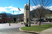 Central monument in the square | |
 | ||||
|
Bright is a beautiful township set in the Ovens Valley on the western
edge of the Alpine National Park. Astride the Ovens River it features both exotic
and Australian trees and some of the walks along the river are breathtaking
in their beauty.
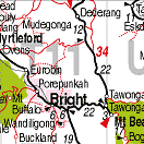
Bright is a staging point for skiiers and sightseers to the Alpine Regions of the Snowy Mountains and Mount Buller and there is plenty of accommodation, provisions and snow and walking equipment available. Great Drives Around Bright 1. Bright - Tower Hill. (8km Return Trip) Drive 2km from Bright towards Porepunkah on the Ovens Hwy. A left turn takes you up a gravelled road to the lookout over Bright with Mt Bogong in the background. Return by same route. 2. Bright - Clearspot. (25km return trip, most on gravel roads) Drive up Baker Gully Rd and continue along signed forest roads through pine plantation to the top. Good views of Mt Buller to the south across to Mt Buller and the ranges. Return by same route. 3. Wandiligong Valley (60km return trip to end of sealed road) Take Wandiligong Rd south from Bright along Morses Creek. Picturesque valley which is classified by the National Trust. Once a gold mining town now with many preserved buildings, also apply orchards, nuts and various horticulture. 4. Bright - Huggins Lookout (20 km, most on gravel roads) A short drive south of Bright from Bakers Gully Road, turning left along gravel road to the lookout. Can be made into a round trip by continuing on this road, then left down Mystic Lane and left again back into Bright 5. Bright - Lake Buffalo. ( 100km round trip, all sealed road) Drive down the Ovens Highway to Myrtleford, then right into the Buffalo Valley Rd to the lake. Fishing, boating, water skiing, designated swimming and picnic areas. 6. Bright - Buckland Valley ( 90 km round trip to end of sealed road) Drive along Ovens Highway to Popepunkah round-a-bout then turn left down Buckland Valley Rd. Road passes through grazing land, tobacco farms and orchards at the foot of Mt Buffalo. Porepunkah airfield is situated along the route. The trip can be continued along gravel road where there are many access points to the river. Return along same route. 7. Bright - Mt Beauty - Alpine National Park ( 150km round trip - sealed roads to Falls Creek) Take the Ovens Hwy south from Bright for 6km, then turn left and follow the road past grazing land and walnut groves climbing to the Tawonga Gap. Good views here from the lookout. The road then drops into the Kiewa Valley, turn right to Tawonga south and Mt Beauty. ( check at the Tourist information Centre (Ph. 03 5757 3172) for details about the Kiewa Hydro Electric Scheme and information on visiting hours for the Hydro Electric Power station situated on the road up to Falls Creek ) Further on, past Mt Beauty (14km) is Bogong Village situated on Lake Guy, well worth a visit especially in autumn and spring. Continue on winding sealed roads to Falls Creek a major ski resort in winter and excellent bushwalking base in summer. The drive across the Bogong High Plains from Falls Creek on gravel roads can include short walks to Wallace or Cope Huts or Mt Cope summit. Return by same route. 8. Bright - Mt Buffalo National Park (80km round trip, all but 6 km on sealed roads) Drive along Ovens Hwy to Porepunkah round-a-bout and follow across round-a-bout to Mt Buffalo Rd and the park entrance (fee $6 summer, $9 winter per car). The road winds up 23km to the plateau, with walks to Eurobin Falls and Rolleston Falls along the way. Once on the plateau you have the options of turning left to see the Mt Buffalo Chalet, Bent's Lookouts and go on the Gorge Nature Walk, or continuing on to Lake Catena, passed Dingo Dell and on to Tart Inn and then to the Horn Lookout. The road from Tatra Inn to The Horn is gravel and closed in winter. Return by the same route. 9. Bright - Harrietville - Mt Hotham - Alpine National Park. (120km - sealed road to Mt Hotham) Travel south along the Ovens Hwy to the historic gold mining town of Harrietville the road climbs up through tall native forests, and is sealed all the way to Mt Hotham Alpine Resort. Breathtaking views lookout over the alpine high country. Many and varied bushwalks can be stared from this area. If you wish the drive can be extended considerably by continuing on to Dinner Plain. Omeo and then the High Plains Road to Falls Creek and Mt Beauty, finishing the route to Bright over the Tawonga Gap. Much of this extension is on gravel roads that often vary in condition. NB: Take care when travelling on gravel roads as some are used by log trucks and also the road surfaces can vary in condition. If in doubt ask the RACV, Tourist information Centre, Dep't of Conservation and Natural Resources or police about current conditions before you go. National Parks Bright is located in the heart of the alpine high country with the Alpine National Park and Mt Buffalo National Park easily accessible. There are thousand of hectares of spectacular mountain scenery, deep river valleys, high plains, granite tors, waterfalls snowgum woodlands and delicate herbfields and wildflowers.Summits of open alpine terrain include the thirteen highest mountains in Victoria within the Alpine shire, including Mt Bogong (Victoria's highest) and Mt Feathertop. Alpine National Park Scenic drives will take you to the park with picnic sites and spectacular views on the way up. In the park there are opportunities for bushwalking, camping, horseriding, fishing, painting, photography or simply enjoying the natural wonders of the high country. Many different length walks are possible from short half -day family walks to overnight ventures. Traditional longer walks include the Razorback track and Bungalow Spur track to Mt Feathertop and the ascent of Mt Bogong via the Staircase Spur. The 400km Alpine Walking Track also traverses the area. Shorter walks to view scenery, summer wildflowers or historic huts are also very popular. Ideal times for walking are summer and autumn but care must be taken at all times as the mountains are notorious for sudden and severe weather changes. Mt Buffalo National Park The 100km of walking tracks in the park provide a variety of long and short walks,. There are also three nature walks with leaflets available at the start of the walk. Magnificent views over the plateau and the surrounding valley and mountains are obtainable from a number of look-outs such as The Horn, Monolith and Mt Dunn. Mt Buffalo provides some of Australia's most challenging rock climbs, and is internationally recognised as a venue for hang-gliding. Holiday Activities Rangers of the National Parks conduct children and family activities during holidays. Programs include slide talks, guided nature walks. "Night Prowls" and Junior Ranger activities. During the snow season there are "Nordic Nature tours" and Snow Shoe Shuffles". Activities are fun, informative and free! Brochures, maps and further information on the national parks are available from the Dep't of Conservation and Natural Resources Bright 03 57551577. Walking track guides may also be available from the Tourist Information Centre, Bright or Harrietville General Store. PLACES OF INTEREST:
INFORMATION CENTRE: Ph: 1800 622 986 HOW TO GET THERE: Take the Hume Highway north from Melbourne to Wangaratta and turn east to the Ovens Hwy. | Light plane to Bright | Some roads may be impassable in the snow season. | Coaches operate from Wangaratta daily | | ||||||||

 |
© Copyright Peter W. Wilkins | |