| CASTLEMAINE - VICTORIA - 3450 | ||||
|---|---|---|---|---|
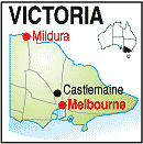 |
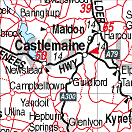
Population: 6820, Elevation: 300, Latitude: 37.04.00 Longitude: 144.15.00 Location: 123km north west of Melbourne Highway: Midland and Calder Hwys Nearest Major Town: Bendigo Nearest Airport: Melbourne Touring Area: Goldfields |
 |
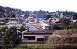 View from the Gaol overlooking Castlemaine. | |
 | ||||
|
Castlemaine is a medium size country town south of Bendigo on the Midland and Pyrenees Highways, just
west of the Calder Highway. Founded on gold after a group of shepherds discovered the precious metal at Forest Creek near Mount Alexander in 1851, by 1852, the area around Castlemaine was the richest shallow, alluvial goldfield in the world. Fortune seekers flocked to the new diggings and new finds in the area attracted even more. From those heady days, it has developed into a pretty tourist centre with many historic old buildings, an historic gaol overlooking the city, and many art and craft galleries. There is a monument to Robert O'Hara Burke on the hill overlooking the town. Burke and Wills were the first Europeans to cross the continent from south to north in a tragic episode which failed on its return leg. Burke was a policeman and superintendent at Castlemaine before the expedition. There are several motels, a Caravan Park, some B&Bs and most services in the town. Nearby Malden is an historic town listed with the National Trust. PLACES OF INTEREST:
INFORMATION CENTRE: Market Building, 44 Mostyn St, Castlemaine VIC 3450 (Near the park) Ph: 03 5470 6200. Email: visitors@mountalexander.vic.gov.au HOW TO GET THERE: Rail, Light Plane to Bendigo then coach, By car or coach along the Calder Hwy from Melbourne or the Midland Hwy from Ballarat or Bendigo. | ||||||||

 |
© Copyright Peter W. Wilkins | |