 |
Koroit Victoria 3282 |
|
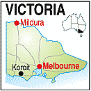
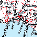
Population: 1200, Elevation: 70m Latitude: -38.2000 Longitude: 142.2200 Location: 290km west of Melbourne Highway: Off Princes Hwy north west of Warrnambool Nearest Major Town: Warrnambool Nearest Airport: Warrnambool Touring Area: The Great Ocean Road | |
|
Historic small township between Warrnambool and Penshurst just north west of Warrnambool. It was surveyed as a township in 1847 although Europeans, particularly Irish, were in the area from the late 1830s. The town is near the dormant volcano and natural attraction of Tower Hill, Victoria's first National Park, and a haven for many native animals including koalas, kangaroos, emus and numerous bird species. There are a number of nature walks within the park, picnic areas with free BBQs and pubic facilities. A Natural History Centre managed by an aboriginal cooperative has authentic art and souvenirs on display, a range of 'bush tucker' for sale, and information about Tower Hill. It is open from 9.00am to 4.30pm daily and access off the Princes Hwy. There is a Visitor Centre in Koroit in Commercial Rd and brochures and maps are available along with personal information on places to see and visit. Take the town Heritage Walk to see many of Koroit's Historic Buildings, or a short drive to Killarney Beach and the safe beach there. There is an Irish Festival held in April-May each year and an agricultural show in November. More Information on their website. . | |
 |
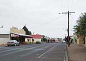 Main street - Koroit |

 |
© Copyright Peter W. Wilkins | |