| MARYBOROUGH - VICTORIA - 3465 | ||||
|---|---|---|---|---|
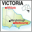 |
Population: 7,740, Elevation: 258, Latitude: -37.0300 Longitude: 143.4500 Location: 165km north west of Melbourne Highway: Pyrenees Hwy Nearest Major Town: Maryborough Nearest Airport: Maryborough Touring Area: Goldfields |
 |
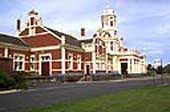 Historic Railway Station. | |
 | ||||
|
Significant town in the Goldfields region. Historic railway station,
large shopping centre. Highlands festival. Information Centre. 8 motels,
3 caravan parks. Several National Parks on the town edge. Airstrip. Now a city of 8,500, it was occupied in the 1840's by graziers until 1854 when a Gold Rush brought large number of miners to nearby White Hills, 5km north. By 1856 High St., was a thriving thoroughfare serving some 50,000 diggers. By 1918 mining petered out and secondary industry took over, making it one of the most highly industrialised towns in Australia. A town tour will give an insight into the town, its historical attractions and amenities. Caravan park; motels, hotels; bowls; lawn tennis; tours. Nearby Talbot, 14km. south, has a number of historic buildings and, in its heyday, had a population of 15,000 and some 50 hotels. PLACES OF INTEREST: Australian Bird Whistling Championships: October. ACCOMMODATION & SERVICES:
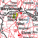
INFORMATION CENTRE: Central Goldfields Visitor Information Centre Cnr. Alma and Nolan Sts. Maryborough. VIC. 3465 Ph: 03 5460 4511. Free Call: 1800 356 511. Email: visitorinfo@origin.net.au HOW TO GET THERE: Rail, Light Plane, By car or coach along the Pyrenees Hwy from Castlemaine or Ararat. Along the Sunraysia Hwy from Avoca. There is an airstrip west of town beside the highway. |


 |
© Copyright Peter W. Wilkins | |