| WOODEND - VICTORIA - 3442 | ||||
|---|---|---|---|---|
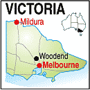 |
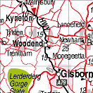
Population: 3010, Elevation: , Latitude: 37.22.00 Longitude: 144.32.00 Location: 70km north west of Melbourne Highway: Calder Hwy Nearest Major Town: Melbourne Nearest Airport: Melbourne Touring Area: Macedon Ranges & Spa Country |
> |
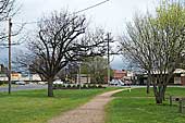 Main street of Woodend. | |
 | ||||
|
Woodend is located 300m above sea level in the Macedon Ranges on a bypass from the
Calder Freeway. The area was home to five aboriginal tribes before being surveyed by
Major Thomas Mitchell who first explored the area in 1836 on his journey through southern New
South Wales and Victoria which opened it up to settlement. Mitchell is remembered in the
Major Mitchell Lookout on nearby Mt. Macedon. The discovery of gold in the area at Bendigo, Castlemaine and Ballarat created a constant flow of miners on their way to and from the diggings and the main street of Woodend flourished. Pastoralists took up the fertile land around the township and in 1862 the railway created easy access to Melbourne. Today Woodend is a popular holiday destination for peole visiting the Macedon Ranges, wineries, Hanging Rock, and the many attractions of the area like cafes, craft shops, gardens and state forests. Contact the local information centre for ideas on what you can see and do on a visit to Woodend and the Macedon Ranges region of Victoria. PLACES OF INTEREST:
EVENTS January
February
March
April
May
July
August
September
October
November
December
INFORMATION CENTRE: Woodend Visitor Information Centre High St. Woodend. Victoria. 3442. Ph: 03 5427 2033. Fax: 03 5427 3917 HOW TO GET THERE: Melbourne: (03) 9467 6111 |


 |
© Copyright Peter W. Wilkins | |